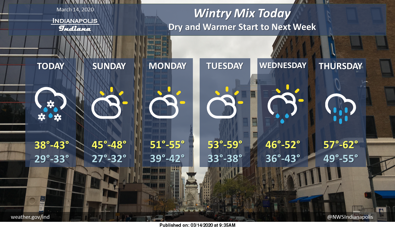
Accumulating snow 1 to 3 inches is expected today near and north of a Muncie to Noblesville to Waveland line.
Elsewhere, rain and snow are likely.
Any snow accumulation will be minimal and limited to grassy surfaces.
Dry conditions move in Sunday and look to stick around through Tuesday.
Via NWS Indianapolis. Follow them on Twitter @NWSIndianapolis for the latest Indianapolis area weather news.
AROUND TWITTER
Sloppy conditions building as road temps drop to freezing near Lebanon — low visibility and slippery roads now. #INwx @wthrcom pic.twitter.com/xG9dmwFDJf
— Lindsey Monroe (@LindseyWTHR13) March 14, 2020
https://twitter.com/bchrisphotos/status/1238836509517713410
The map I showed throughout the newscast. Still thinking this is the correct zone for snow accumulation. Wouldn't be surprised to see isolated 2" to 3" in spots NW. (Especially where the heavier snow band developed.) #INwx @FOX59 @theWXauthority pic.twitter.com/6NPZmNo9KS
— Amber Hardwick (@AHardwickWx) March 14, 2020
Say it ain't snow! Sticking NW of Indy metro right now! INDOT camera just north of Lebanon! Road conditions are becoming slick… #INwx pic.twitter.com/GhOVhwbxYW
— Amber Hardwick (@AHardwickWx) March 14, 2020
Snowy scenes in Tipton and Noblesville mostly accumulating on grass and minimal impacts to roads at this time #INwx pic.twitter.com/D9ZOGwAwWk
— Sean Ash (@SeanAshWX) March 14, 2020
It's a chilly and damp start to the weekend. Here's your Saturday forecast. @rtv6 #INwx pic.twitter.com/uwNDbxozUD
— Kyle Mounce (@kylemounce) March 14, 2020
1/ IMPORTANT NOTE: Out of an abundance of caution for COVID-19 & in order to protect our staff as well as the public, all remaining NWS Storm Spotter Classes across central Indiana have been POSTPONED effective immediately. #INwx #Indy #skywarn
— NWS Indianapolis (@NWSIndianapolis) March 12, 2020