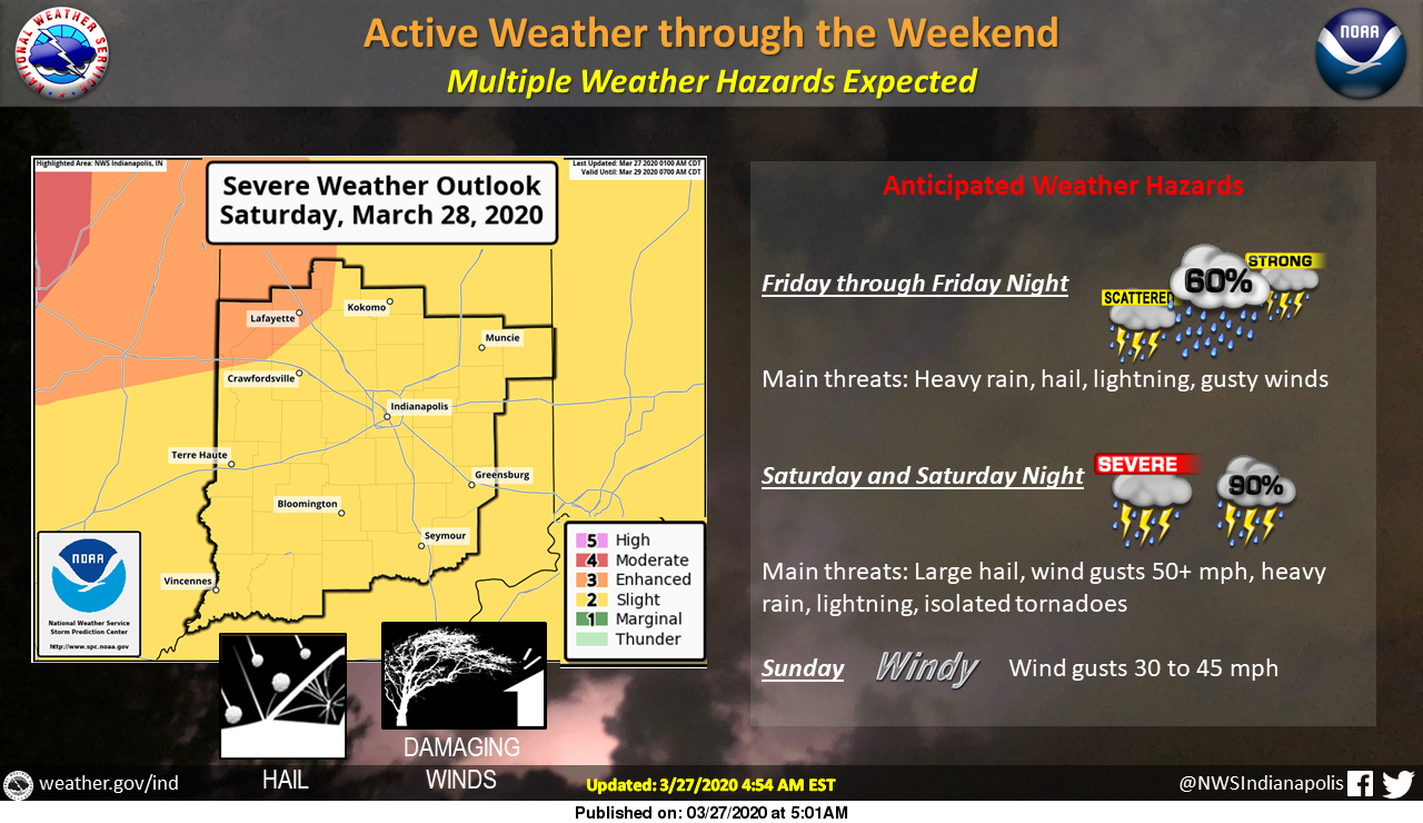
An active weather pattern is expected for the end of the week and through the weekend.
Isolated to scattered thunderstorms are expected today and tonight, a few of which could be strong to severe.
There is a SLIGHT RISK for severe weather for much of Central Indiana, along with an ENHANCED RISK for Severe Weather in Northwest Indiana on Saturday.
Hail, heavy rain, lightning, and damaging winds will be the main threats today and Saturday.
Sunday the storms will be out of the area, but strong winds of 20 to 30 mph with gusts to 40 mph will develop.
Stay Weather Aware this weekend!
Via NWS Indianapolis. Follow them on Twitter @NWSIndianapolis for the latest Indianapolis area weather news.
AROUND TWITTER
A few strong storms with hail, heavy rain and lightning Friday-Friday night. Some severe storms on tap for Saturday-Saturday night with large hail, strong winds, heavy rain and lightning. Windy Sunday. #INwx pic.twitter.com/MB6RxFo7Cn
— NWS Indianapolis (@NWSIndianapolis) March 26, 2020
Friday will bring a marginal risk for severe storms to central Indiana, along with a slight risk of excessive rainfall. #INwx pic.twitter.com/Nq7IF61ktV
— NWS Indianapolis (@NWSIndianapolis) March 26, 2020
Slight risk of severe storms Saturday, with threats for large hail, lightning, damaging winds and heavy rain. Stay weather aware. #INwx pic.twitter.com/AtblwePEpI
— NWS Indianapolis (@NWSIndianapolis) March 27, 2020
Storms are weakening in our southern counties at this hour. Still expect moderate rainfall, isolated downpours and lightning. #INwx @FOX59 @theWXauthority #FOX59morning pic.twitter.com/I9OnWJlQbB
— Amber Hardwick (@AHardwickWx) March 27, 2020
Strong storms today. An elevated risk tomorrow late evening and overnight. Please have a way of getting alerts ALL modes of severe weather are in play, tornadoes, hail, gusty winds. @WISH_TV #INwx #Indy https://t.co/9uWOcr6BSG pic.twitter.com/cQTmhW04yN
— Stephanie Mead (@stephmeadwx) March 27, 2020
Amber's #Doodlecast >> March is National Umbrella ☔️ Month… Who knew?! Need one today… widely scattered showers and t-storms. High: 64° 😁⛈ @fox59 #FOX59morning #INwx pic.twitter.com/tePhfbmKGt
— Amber Hardwick (@AHardwickWx) March 27, 2020
Next two days looks active. Storms today and tomorrow. Isolated stronger storms today with large hail. Better chance for all severe weather modes, tornadoes, hail, wind and flooding Saturday afternoon/eve. Have ways to get alerts. @WISH_TV #INwx #Indy pic.twitter.com/RUveyVlwoS
— Stephanie Mead (@stephmeadwx) March 27, 2020