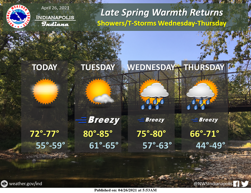
Plentiful sunshine will boost temperatures into the 70s for the first time in over two weeks today.
Robust southwesterly breezes Tuesday will then bring the first 80's of the year.
Expect a transition to widespread rain showers and a few thunderstorms mid-week.
INDIANAPOLIS 7-DAY EXTENDED FORECAST
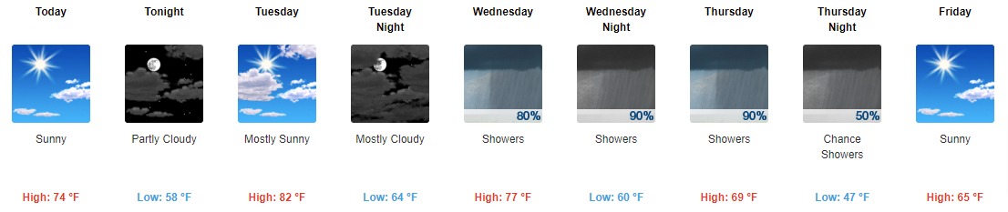
Today: Sunny, with a high near 74. South wind 6 to 14 mph, with gusts as high as 21 mph.
Tonight: Partly cloudy, with a low around 58. South wind 11 to 16 mph, with gusts as high as 20 mph.
Tuesday: Mostly sunny, with a high near 82. South southwest wind 10 to 18 mph, with gusts as high as 30 mph.
Tuesday Night: Mostly cloudy, with a low around 64. South southwest wind 13 to 16 mph, with gusts as high as 24 mph.
Wednesday: Showers and possibly a thunderstorm, mainly after 3 pm. High near 77. Southwest wind 11 to 13 mph, with gusts as high as 22 mph. The chance of precipitation is 80%. New rainfall amounts between a tenth and quarter of an inch, except higher amounts possible in thunderstorms.
Wednesday Night: Showers and possibly a thunderstorm. Low around 60. The chance of precipitation is 90%. New rainfall amounts between three-quarters and one inch possible.
Thursday: Showers and possibly a thunderstorm, mainly before 3 pm, then a chance of showers and thunderstorms after 3 pm. High near 69. The chance of precipitation is 90%.
Thursday Night: A chance of showers and thunderstorms before 9 pm, then a chance of showers between 9 pm and 3 am. Mostly cloudy, with a low around 47. The chance of precipitation is 50%.
Friday: Sunny, with a high near 65.
Friday Night: Mostly clear, with a low around 44.
Saturday: Sunny, with a high near 69.
Saturday Night: Mostly clear, with a low around 50.
Sunday: A 20 percent chance of showers. Mostly sunny, with a high near 73.
THE UNITED STATES OF AMERICA 3-DAY OUTLOOK


SOURCE: NWS Indianapolis.
Follow NWS Indianapolis on Twitter @NWSIndianapolis for the latest Indianapolis area weather news.