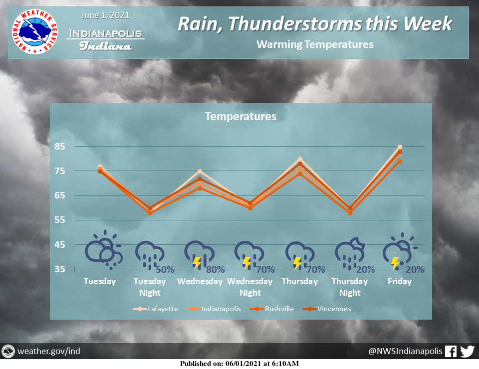
Rain and thunderstorms are returning to the area starting as early as this afternoon.
Locally heavy rain is also possible tomorrow.
Temperatures will gradually warm through the week, reaching the 80s by Friday.
INDIANAPOLIS 7-DAY EXTENDED FORECAST
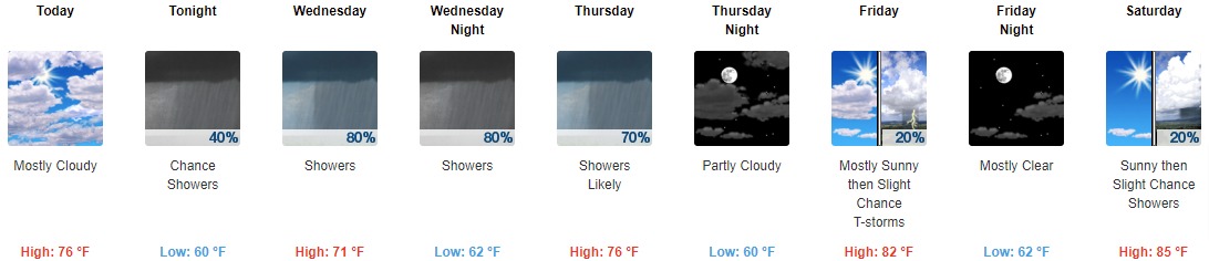
Today: Mostly cloudy, with a high near 76. Calm wind becoming south southeast around 5 mph in the afternoon.
Tonight: A 40 percent chance of showers, mainly after midnight. Cloudy, with a low around 60. South wind 3 to 6 mph.
Wednesday: Showers likely, then showers and possibly a thunderstorm after 2 pm. High near 71. Southeast wind around 6 mph. The chance of precipitation is 80%. New rainfall amounts between a quarter and half of an inch possible.
Wednesday Night: Showers and possibly a thunderstorm. Low around 62. Southeast wind 3 to 6 mph. The chance of precipitation is 80%. New rainfall amounts between a tenth and quarter of an inch, except higher amounts possible in thunderstorms.
Thursday: Showers likely and possibly a thunderstorm. Mostly cloudy, with a high near 76. Light and variable wind becoming west northwest around 6 mph in the afternoon. The chance of precipitation is 70%. New rainfall amounts between a quarter and half of an inch possible.
Thursday Night: Partly cloudy, with a low around 60.
Friday: A 20 percent chance of showers and thunderstorms after 2 pm. Mostly sunny, with a high near 82.
Friday Night: Mostly clear, with a low around 62.
Saturday: A 20 percent chance of showers after 2 pm. Sunny, with a high near 85.
Saturday Night: A 10 percent chance of showers before 8 pm. Mostly clear, with a low around 64.
Sunday: A 20 percent chance of showers. Mostly sunny, with a high near 86.
Sunday Night: A 10 percent chance of showers. Partly cloudy, with a low around 65.
Monday: A 40 percent chance of showers and thunderstorms. Mostly sunny, with a high near 87.
THE UNITED STATES OF AMERICA 3-DAY OUTLOOK


SOURCE: NWS Indianapolis.
Follow NWS Indianapolis on Twitter @NWSIndianapolis for the latest Indianapolis area weather news.