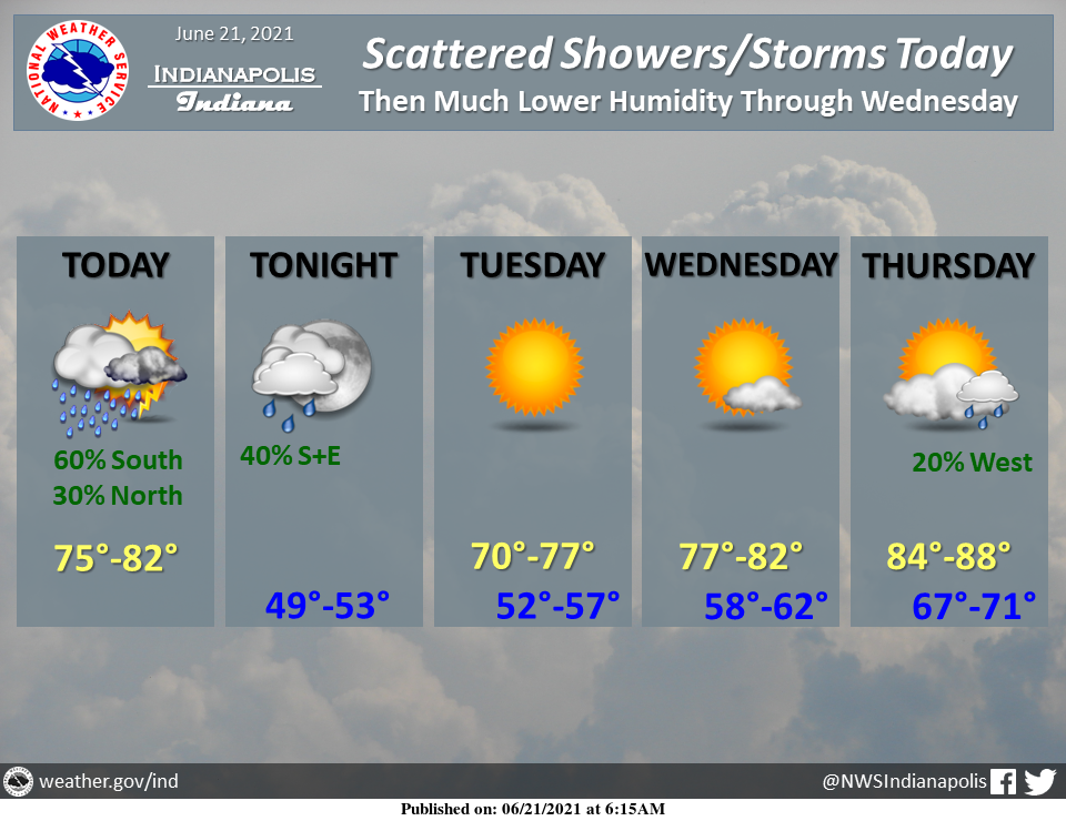
Isolated to scattered showers and a few thunderstorms will cross the region from west to east today, with the greatest coverage south of I-70.
Northwesterly breezes and clearing skies tonight will bring an unseasonably cool Tuesday.
Mid-week will be dry amid a gradual return to summerlike conditions.
INDIANAPOLIS 7-DAY EXTENDED FORECAST

Today: A chance of showers and thunderstorms before 1 pm, then a chance of showers between 1 pm and 4 pm, then a chance of showers and thunderstorms after 4 pm. Partly sunny, with a steady temperature around 75. West northwest wind 11 to 14 mph, with gusts as high as 21 mph. The chance of precipitation is 40%.
Tonight: A chance of showers and thunderstorms before 9 pm, then a slight chance of showers between 9 pm and midnight. Cloudy during the early evening, then gradual clearing, with a low around 53. Northwest wind 5 to 9 mph becoming light and variable after midnight. The chance of precipitation is 30%.
Tuesday: Sunny, with a high near 73. Calm wind becoming north northwest around 6 mph in the afternoon.
Tuesday Night: Mostly clear, with a low around 55. West wind around 5 mph becoming light and variable after midnight.
Wednesday: Mostly sunny, with a high near 80. South wind 5 to 9 mph.
Wednesday Night: Mostly clear, with a low around 60.
Thursday: Mostly sunny, with a high near 87.
Thursday Night: A 30 percent chance of showers, mainly after 2 am. Mostly cloudy, with a low around 70.
Friday: A chance of showers and thunderstorms, then showers likely and possibly a thunderstorm after 2 pm. Mostly cloudy, with a high near 82. The chance of precipitation is 70%.
Friday Night: Showers likely and possibly a thunderstorm. Mostly cloudy, with a low around 69. The chance of precipitation is 70%.
Saturday: Showers likely and possibly a thunderstorm. Mostly cloudy, with a high near 80. The chance of precipitation is 70%.
Saturday Night: A 50 percent chance of showers and thunderstorms. Mostly cloudy, with a low around 63.
Sunday: A 40 percent chance of showers. Mostly sunny, with a high near 80.
THE UNITED STATES OF AMERICA 3-DAY OUTLOOK


SOURCE: NWS Indianapolis.
Follow NWS Indianapolis on Twitter @NWSIndianapolis for the latest Indianapolis area weather news.