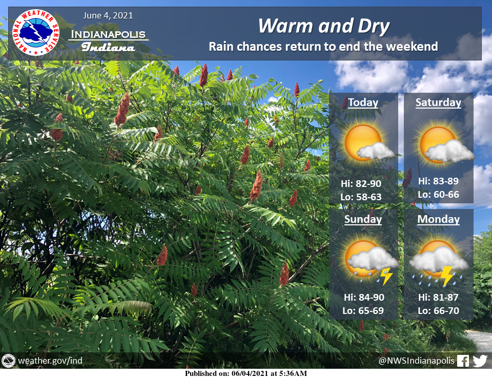
Warm and dry conditions are expected across central Indiana today and into the weekend with highs in the 80s to around 90.
Rain chances along with the potential for a few thunderstorms return to end the weekend.
INDIANAPOLIS 7-DAY EXTENDED FORECAST
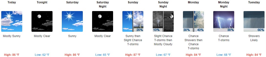
Today: Mostly sunny, with a high near 86. West southwest wind 5 to 9 mph.
Tonight: Mostly clear, with a low around 62. South southwest wind 3 to 7 mph.
Saturday: Sunny, with a high near 86. Light south southwest wind becoming southwest 5 to 9 mph in the morning.
Saturday Night: Mostly clear, with a low around 65. South southwest wind 5 to 7 mph becoming calm after midnight.
Sunday: A 20 percent chance of showers and thunderstorms after 2 pm. Mostly sunny, with a high near 87. Calm wind becoming south southwest 5 to 9 mph in the morning.
Sunday Night: A 10 percent chance of showers and thunderstorms before 8 pm. Partly cloudy, with a low around 67.
Monday: A 40 percent chance of showers and thunderstorms. Partly sunny, with a high near 84.
Monday Night: A 30 percent chance of showers and thunderstorms, mainly before 8 pm. Mostly cloudy, with a low around 68.
Tuesday: A chance of showers and thunderstorms between 8 am and 2 pm, then showers likely and possibly a thunderstorm after 2 pm. Mostly cloudy, with a high near 84. The chance of precipitation is 60%.
Tuesday Night: Showers likely and possibly a thunderstorm before 8 pm, then a chance of showers and thunderstorms between 8 pm and 2 am, then a slight chance of showers after 2 am. Mostly cloudy, with a low around 69. The chance of precipitation is 60%.
Wednesday: A 50 percent chance of showers and thunderstorms. Partly sunny, with a high near 85.
Wednesday Night: A 30 percent chance of showers and thunderstorms. Mostly cloudy, with a low around 68.
Thursday: A 40 percent chance of showers and thunderstorms. Partly sunny, with a high near 86.
THE UNITED STATES OF AMERICA 3-DAY OUTLOOK


SOURCE: NWS Indianapolis.
Follow NWS Indianapolis on Twitter @NWSIndianapolis for the latest Indianapolis area weather news.