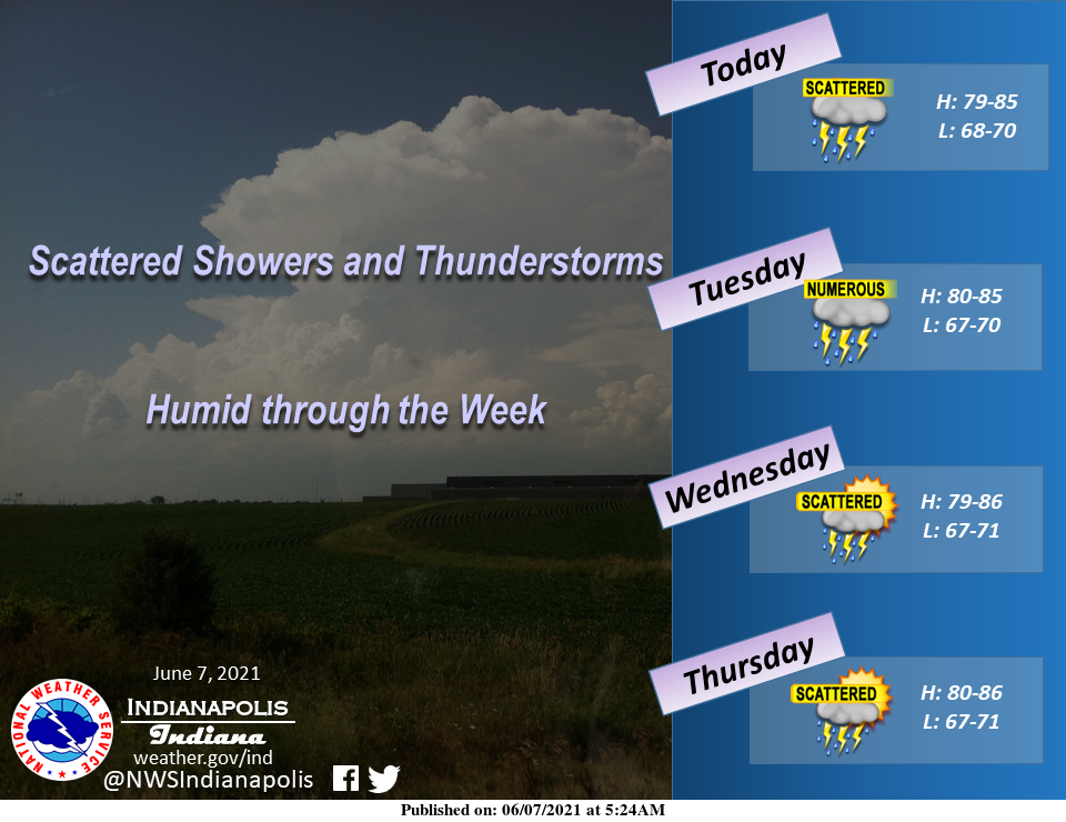
Scattered showers and thunderstorms, peaking in coverage in the afternoon and evening most days, will be the rule this week across central Indiana as humid air is entrenched across the area.
The main threats from these storms will be lightning and localized heavy rainfall that could lead to flooding.
High temperatures will be in the upper 70s to middle 80s, and lows will be in the upper 60s to lower 70s.
INDIANAPOLIS 7-DAY EXTENDED FORECAST
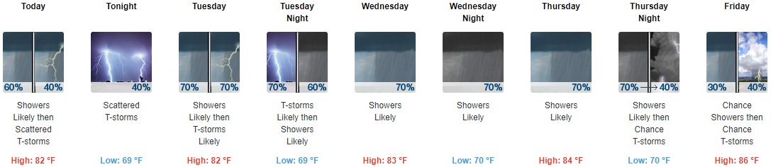
Today: Showers likely and possibly a thunderstorm before 11 am, then scattered showers and thunderstorms after 11 am. Cloudy, with a high near 82. South southwest wind around 8 mph. The chance of precipitation is 60%. New rainfall amounts between a tenth and quarter of an inch, except higher amounts possible in thunderstorms.
Tonight: Scattered showers and thunderstorms, mainly before midnight. Mostly cloudy, with a low around 69. South wind 6 to 8 mph. The chance of precipitation is 40%.
Tuesday: Scattered showers and thunderstorms before 9 am, then showers likely and possibly a thunderstorm between 9 am and 3 pm, then showers and thunderstorms likely after 3 pm. Mostly cloudy, with a high near 82. South wind 3 to 7 mph. The chance of precipitation is 70%. New rainfall amounts between a tenth and quarter of an inch, except higher amounts possible in thunderstorms.
Tuesday Night: Showers and thunderstorms likely before 9 pm, then showers likely and possibly a thunderstorm between 9 pm and 3 am, then a chance of showers and thunderstorms after 3 am. Mostly cloudy, with a low around 69. South wind around 6 mph. The chance of precipitation is 70%. New rainfall amounts between a quarter and half of an inch possible.
Wednesday: A chance of showers and thunderstorms, then showers likely and possibly a thunderstorm after 9 am. Mostly cloudy, with a high near 83. South wind 5 to 7 mph. The chance of precipitation is 70%. New rainfall amounts between a quarter and half of an inch possible.
Wednesday Night: Showers likely and possibly a thunderstorm before 3 am, then a chance of showers and thunderstorms after 3 am. Mostly cloudy, with a low around 70. The chance of precipitation is 70%. New rainfall amounts between a tenth and quarter of an inch, except higher amounts possible in thunderstorms.
Thursday: A chance of showers and thunderstorms, then showers likely and possibly a thunderstorm after 3 pm. Mostly cloudy, with a high near 84. The chance of precipitation is 70%.
Thursday Night: Showers likely and possibly a thunderstorm before 9 pm, then a chance of showers and thunderstorms between 9 pm and 3 am, then a chance of showers after 3 am. Mostly cloudy, with a low around 70. The chance of precipitation is 70%.
Friday: A chance of showers, with thunderstorms also possible after 9 am. Partly sunny, with a high near 86. The chance of precipitation is 40%.
Friday Night: A 40 percent chance of showers and thunderstorms, mainly before 9 pm. Partly cloudy, with a low around 69.
Saturday: A 30 percent chance of showers and thunderstorms. Mostly sunny, with a high near 88.
Saturday Night: A 30 percent chance of showers and thunderstorms. Partly cloudy, with a low around 66.
Sunday: Mostly sunny, with a high near 85.
THE UNITED STATES OF AMERICA 3-DAY OUTLOOK


SOURCE: NWS Indianapolis.
Follow NWS Indianapolis on Twitter @NWSIndianapolis for the latest Indianapolis area weather news.