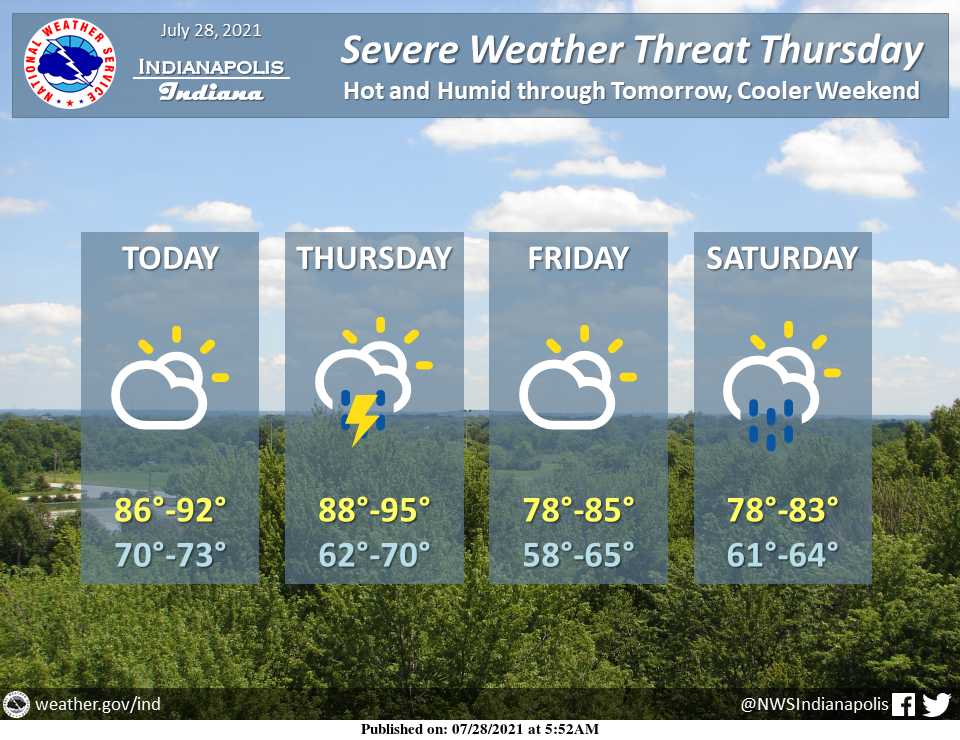
Heat continues into tomorrow with heat indices in the upper 90s to above 100.
Thunderstorms are expected Thursday and could produce severe weather.
Then temperatures finally cool off some starting Friday.
INDIANAPOLIS 7-DAY EXTENDED FORECAST
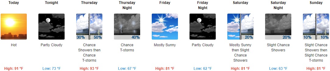
Today: Mostly sunny and hot, with a high near 91. Calm wind becoming west northwest around 6 mph in the afternoon.
Tonight: Partly cloudy, with a low around 73. West wind around 6 mph becoming calm in the evening.
Thursday: A chance of showers, with thunderstorms also possible after 11am. Mostly sunny and hot, with a high near 93. Southwest wind 6 to 13 mph, with gusts as high as 18 mph. The chance of precipitation is 50%. New rainfall amounts of less than a tenth of an inch, except higher amounts possible in thunderstorms.
Thursday Night: A 40 percent chance of showers and thunderstorms before 2am. Partly cloudy, with a low around 67. North northwest wind 6 to 10 mph.
Friday: Mostly sunny, with a high near 81. North wind around 9 mph.
Friday Night: Partly cloudy, with a low around 62.
Saturday: A 20 percent chance of showers after 2pm. Mostly sunny, with a high near 81.
Saturday Night: A 20 percent chance of showers. Partly cloudy, with a low around 63.
Sunday: A slight chance of showers, with thunderstorms also possible after 2pm. Sunny, with a high near 81. The chance of precipitation is 10%.
Sunday Night: A slight chance of thunderstorms before 8pm. Mostly clear, with a low around 59. The chance of precipitation is 10%.
Monday: A 10 percent chance of showers and thunderstorms. Sunny, with a high near 80.
Monday Night: Mostly clear, with a low around 59.
Tuesday: Sunny, with a high near 82.
THE UNITED STATES OF AMERICA 3-DAY OUTLOOK


SOURCE: NWS Indianapolis.
Follow NWS Indianapolis on Twitter @NWSIndianapolis for the latest Indianapolis area weather news.