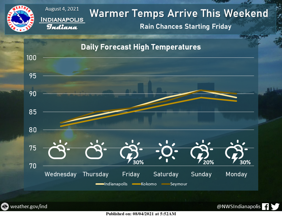
Enjoy the last few days of mild weather before the heat returns to end the week.
Chances for rain enter the forecast starting Friday, primarily for locations northwest of Indianapolis.
INDIANAPOLIS 7-DAY EXTENDED FORECAST
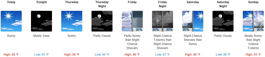
Today: Sunny, with a high near 82. Northeast wind 3 to 7 mph.
Tonight: Mostly clear, with a low around 61. North northeast wind 3 to 6 mph.
Thursday: Sunny, with a high near 84. Calm wind becoming southeast around 5 mph in the afternoon.
Thursday Night: Partly cloudy, with a low around 65. South southwest wind around 5 mph becoming calm in the evening.
Friday: A 20 percent chance of showers after 3pm. Partly sunny, with a high near 86. Light south wind becoming southwest 5 to 9 mph in the morning.
Friday Night: A slight chance of showers and thunderstorms. Partly cloudy, with a low around 67. The chance of precipitation is 20%.
Saturday: A 20 percent chance of showers before 9am. Sunny, with a high near 88.
Saturday Night: Partly cloudy, with a low around 69.
Sunday: A 20 percent chance of showers and thunderstorms after 3pm. Mostly sunny and hot, with a high near 91.
Sunday Night: A slight chance of showers and thunderstorms before 9pm, then a slight chance of showers after 3am. Partly cloudy, with a low around 73. The chance of precipitation is 20%.
Monday: A 40 percent chance of showers and thunderstorms. Partly sunny and hot, with a high near 91.
Monday Night: A 40 percent chance of showers and thunderstorms. Partly cloudy, with a low around 73.
Tuesday: A 40 percent chance of showers and thunderstorms. Mostly sunny and hot, with a high near 92.
THE UNITED STATES OF AMERICA 3-DAY OUTLOOK


SOURCE: NWS Indianapolis.
Follow NWS Indianapolis on Twitter @NWSIndianapolis for the latest Indianapolis area weather news.