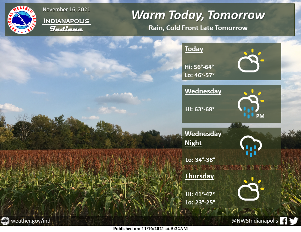
Enjoy the warmth today and tomorrow before it quickly leaves again.
A cold front will push a line of rain across the area from tomorrow afternoon to overnight and then drop temperatures back to below normal.
INDIANAPOLIS 7-DAY EXTENDED FORECAST
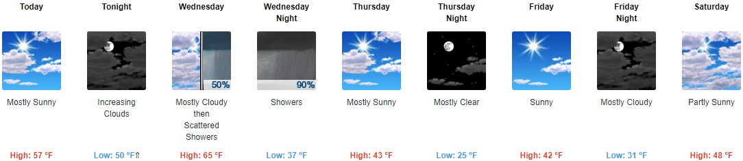
Today: Mostly sunny, with a high near 57. Southeast wind 5 to 8 mph.
Tonight: Increasing clouds, with a temperature falling to near 50 by 9pm, then rising to around 58 during the remainder of the night. Southeast wind 8 to 13 mph, with gusts as high as 25 mph.
Wednesday: Scattered showers after 2pm. Mostly cloudy, with a high near 65. South southwest wind 14 to 16 mph, with gusts as high as 31 mph. The chance of precipitation is 50%. New precipitation amounts of less than a tenth of an inch are possible.
Wednesday Night: Showers, mainly after 8pm. Low around 37. Southwest wind 8 to 14 mph becoming northwest after midnight. Winds could gust as high as 26 mph. The chance of precipitation is 90%. New precipitation amounts between a quarter and half of an inch possible.
Thursday: Mostly sunny, with a high near 43. West wind 7 to 14 mph, with gusts as high as 22 mph.
Thursday Night: Mostly clear, with a low around 25.
Friday: Sunny, with a high near 42.
Friday Night: Mostly cloudy, with a low around 31.
Saturday: Partly sunny, with a high near 48.
Saturday Night: A 20 percent chance of showers after 8pm. Mostly cloudy, with a low around 37.
Sunday: A 20 percent chance of showers. Partly sunny, with a high near 51.
Sunday Night: A chance of rain and snow showers. Mostly cloudy, with a low around 30. The chance of precipitation is 40%.
Monday: A chance of rain and snow showers. Mostly sunny, with a high near 40. The chance of precipitation is 40%.
THE UNITED STATES OF AMERICA 3-DAY OUTLOOK


SOURCE: NWS Indianapolis.
Follow NWS Indianapolis on Twitter @NWSIndianapolis for the latest Indianapolis area weather news.