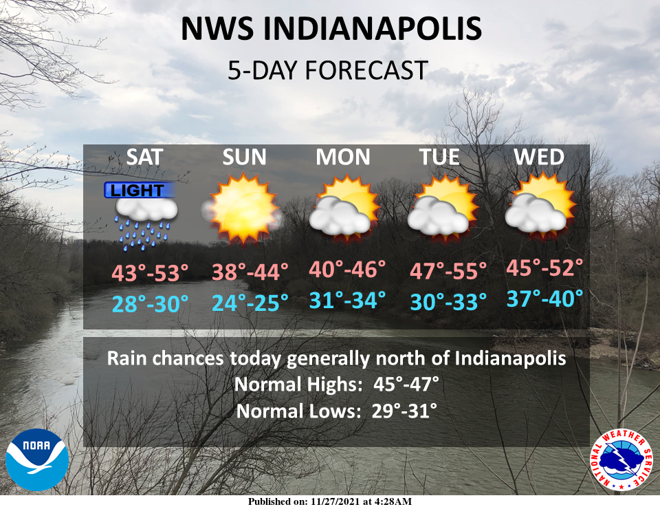
Isolated rain and sprinkles will move through north-central Indiana today with near to slightly above normal temperatures today.
Mostly sunny to partly cloudy skies are expected through much of next week with gradually warming temperatures.
INDIANAPOLIS 7-DAY EXTENDED FORECAST
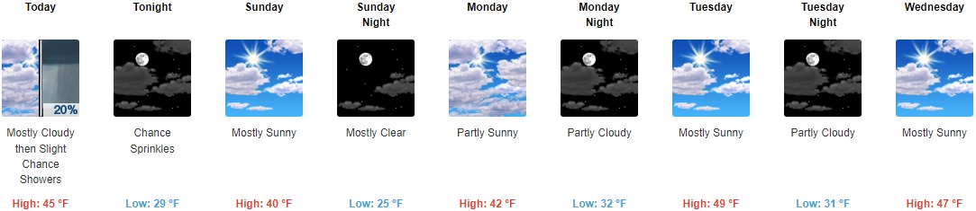
Today: A chance of sprinkles between 1pm and 3pm, then a slight chance of showers after 3pm. Mostly cloudy, with a high near 45. South southwest wind around 10 mph, with gusts as high as 20 mph. The chance of precipitation is 20%.
Tonight: A chance of sprinkles before 7pm. Partly cloudy, with a low around 29. Southwest wind 8 to 11 mph becoming northwest after midnight. Winds could gust as high as 18 mph.
Sunday: Mostly sunny, with a high near 40. West northwest wind 9 to 15 mph, with gusts as high as 22 mph.
Sunday Night: Mostly clear, with a low around 25. West northwest wind 5 to 7 mph becoming calm after midnight.
Monday: Partly sunny, with a high near 42. Calm wind becoming south southwest 5 to 9 mph in the afternoon.
Monday Night: Partly cloudy, with a low around 32.
Tuesday: Mostly sunny, with a high near 49.
Tuesday Night: Partly cloudy, with a low around 31.
Wednesday: Mostly sunny, with a high near 47.
Wednesday Night: Mostly cloudy, with a low around 38.
Thursday: Mostly sunny, with a high near 55.
Thursday Night: Partly cloudy, with a low around 41.
Friday: A 30 percent chance of rain. Mostly sunny, with a high near 55.
THE UNITED STATES OF AMERICA 3-DAY OUTLOOK


SOURCE: NWS Indianapolis.
Follow NWS Indianapolis on Twitter @NWSIndianapolis for the latest Indianapolis area weather news.