
Temperatures common for October will continue through Wednesday.
Variable cloudiness will surround a few showers Tuesday night … before a seasonably strong cold front brings more widespread rain and robust breezes on Thursday.
INDIANAPOLIS 7-DAY EXTENDED FORECAST
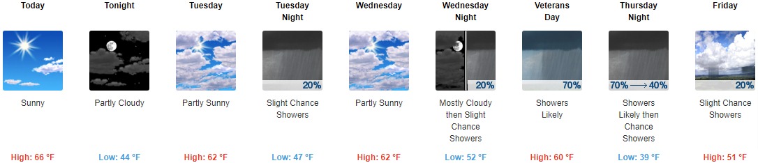
Today: Sunny, with a high near 66. Southwest wind 6 to 10 mph, with gusts as high as 20 mph.
Tonight: Partly cloudy, with a low around 44. South southwest wind 3 to 6 mph.
Tuesday: Partly sunny, with a high near 62. South wind 3 to 7 mph.
Tuesday Night: A slight chance of showers between 8pm and 2am. Mostly cloudy, with a low around 47. Southwest wind around 5 mph becoming calm in the evening. The chance of precipitation is 20%.
Wednesday: Partly sunny, with a high near 62. Light and variable wind becoming east southeast 5 to 7 mph in the morning.
Wednesday Night: A 20 percent chance of showers after 2am. Mostly cloudy, with a low around 52.
Veterans Day: Showers likely, mainly after 8am. Mostly cloudy, with a high near 60. The chance of precipitation is 70%.
Thursday Night: Showers likely, mainly before 8pm. Mostly cloudy, with a low around 39. The chance of precipitation is 70%.
Friday: A slight chance of showers before 8am, then a slight chance of showers after 2pm. Mostly sunny, with a high near 51. The chance of precipitation is 20%.
Friday Night: A 20 percent chance of showers before 8pm. Mostly cloudy, with a low around 34.
Saturday: A 20 percent chance of showers. Partly sunny, with a high near 41.
Saturday Night: A slight chance of rain and snow showers. Mostly cloudy, with a low around 33. The chance of precipitation is 20%.
Sunday: A slight chance of rain and snow showers. Partly sunny, with a high near 43. The chance of precipitation is 20%.
THE UNITED STATES OF AMERICA 3-DAY OUTLOOK


SOURCE: NWS Indianapolis.
Follow NWS Indianapolis on Twitter @NWSIndianapolis for the latest Indianapolis area weather news.