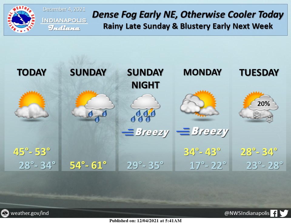
Watch out for visibility possibly under ј mile in dense fog early today northeast of Indianapolis.
Conditions will be dry and generally seasonable today and tonight.
Winds will increase Sunday as rain showers expand across the region…with widespread rain and gusts up to 30 mph Sunday Night.
INDIANAPOLIS 7-DAY EXTENDED FORECAST

Today: Mostly sunny, with a high near 48. North wind around 8 mph.
Tonight: Partly cloudy, with a low around 31. North northeast wind around 7 mph becoming east after midnight.
Sunday: Showers likely after 1pm. Increasing clouds, with a high near 57. East wind 9 to 13 mph becoming south in the afternoon. Winds could gust as high as 23 mph. The chance of precipitation is 70%. New precipitation amounts of less than a tenth of an inch are possible.
Sunday Night: Showers, mainly before 1am. Low around 32. South wind 10 to 14 mph becoming west after midnight. Winds could gust as high as 28 mph. The chance of precipitation is 100%. New precipitation amounts between a quarter and half of an inch possible.
Monday: Mostly sunny, with a high near 38. West wind 14 to 16 mph, with gusts as high as 26 mph.
Monday Night: Partly cloudy, with a low around 19.
Tuesday: A 20 percent chance of snow after 1pm. Partly sunny, with a high near 30.
Tuesday Night: A 50 percent chance of snow. Mostly cloudy, with a low around 26.
Wednesday: A 20 percent chance of snow before 1pm. Partly sunny, with a high near 36.
Wednesday Night: Partly cloudy, with a low around 24.
Thursday: A 20 percent chance of showers. Partly sunny, with a high near 40.
Thursday Night: A 20 percent chance of showers. Mostly cloudy, with a low around 33.
Friday: A 20 percent chance of showers. Mostly cloudy, with a high near 48.
THE UNITED STATES OF AMERICA 3-DAY OUTLOOK


SOURCE: NWS Indianapolis.
Follow NWS Indianapolis on Twitter @NWSIndianapolis for the latest Indianapolis area weather news.