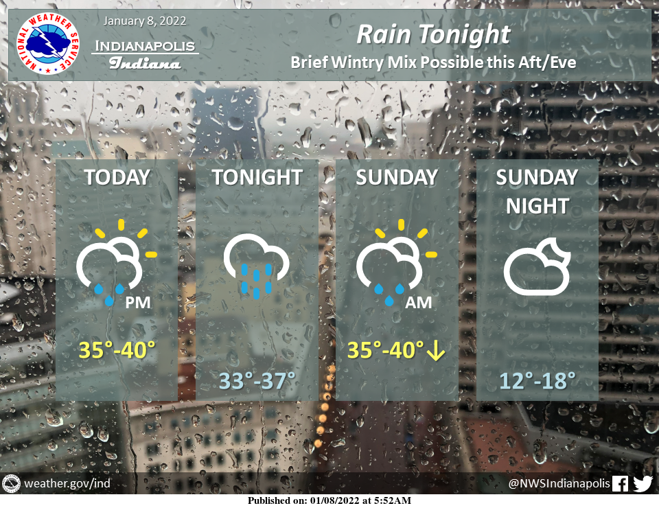
Rain will move in from the west this afternoon to evening and end tomorrow morning.
As precipitation begins, sleet/freezing rain may mix in briefly, along and north of I-70, before becoming all rain.
Watch out for slick spots on roads later today.
Some snow may also mix in tomorrow morning briefly before precipitation comes to an end.
Today's high temperatures will occur late this afternoon into tonight while temperatures will drop throughout the day tomorrow.
INDIANAPOLIS 7-DAY EXTENDED FORECAST
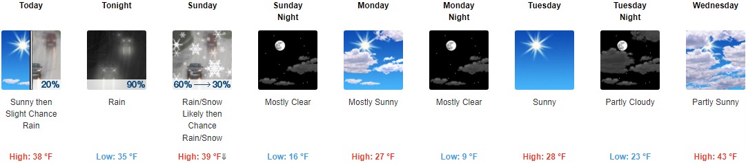
Today: A 20 percent chance of rain after 4pm. Increasing clouds, with a high near 38. South southeast wind 10 to 13 mph, with gusts as high as 23 mph.
Tonight: Rain. Low around 35. South wind 10 to 14 mph, with gusts as high as 25 mph. The chance of precipitation is 90%. New precipitation amounts between a quarter and half of an inch possible.
Sunday: Rain likely, possibly mixing with snow after 9am, then gradually ending. Cloudy, then gradually becoming mostly sunny, with a temperature falling to around 28 by 5pm. West southwest wind 7 to 14 mph becoming north northwest in the afternoon. Winds could gust as high as 23 mph. The chance of precipitation is 60%. Little or no snow accumulation is expected.
Sunday Night: Mostly clear, with a low around 16. Northwest wind 6 to 9 mph.
Monday: Mostly sunny, with a high near 27. West wind 6 to 13 mph, with gusts as high as 21 mph.
Monday Night: Mostly clear, with a low around 9.
Tuesday: Sunny, with a high near 28.
Tuesday Night: Partly cloudy, with a low around 23.
Wednesday: Partly sunny, with a high near 43.
Wednesday Night: Mostly cloudy, with a low around 32.
Thursday: Mostly sunny, with a high near 43.
Thursday Night: Mostly cloudy, with a low around 31.
Friday: A 40 percent chance of showers. Mostly cloudy, with a high near 43.
THE UNITED STATES OF AMERICA 3-DAY OUTLOOK


SOURCE: NWS Indianapolis.
Follow NWS Indianapolis on Twitter @NWSIndianapolis for the latest Indianapolis area weather news.