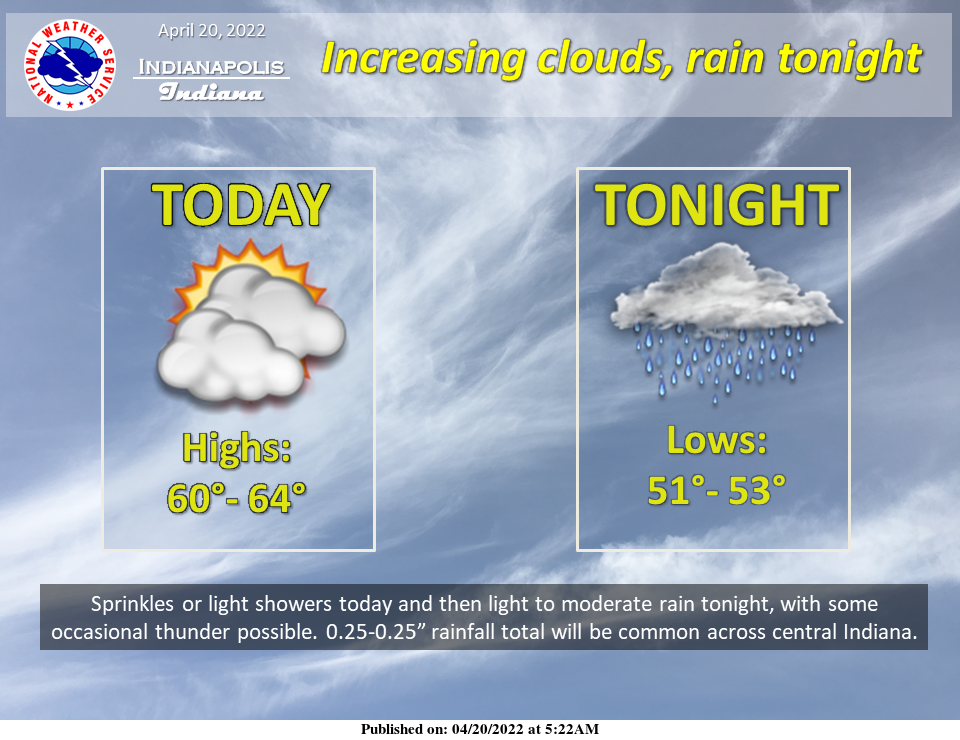
Clouds will increase today with occasional sprinkles or light showers amounting to very little. Light to moderate rain will increase tonight with 0.25-0.50″ total at most locations across central Indiana by Thursday morning. A significant warming trend is expected Thursday into the weekend.
INDIANAPOLIS 7-DAY EXTENDED FORECAST
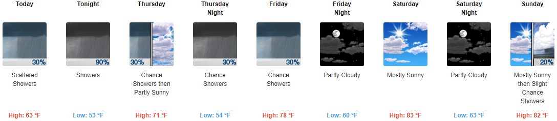
Today: Scattered showers, mainly before noon. Mostly cloudy, with a high near 63. South southeast wind 10 to 14 mph, with gusts as high as 23 mph. The chance of precipitation is 30%.
Tonight: Showers, mainly after 8pm. Low around 53. South wind 16 to 18 mph, with gusts as high as 31 mph. The chance of precipitation is 90%. New precipitation amounts between a quarter and half of an inch possible.
Thursday: A 30 percent chance of showers, mainly before 8am. Mostly cloudy, with a high near 71. West wind 9 to 14 mph, with gusts as high as 22 mph.
Thursday Night: A 30 percent chance of showers, mainly after 2am. Mostly cloudy, with a low around 54. Light and variable wind.
Friday: A 30 percent chance of showers before 2pm. Mostly cloudy, with a high near 78. South wind 5 to 10 mph, with gusts as high as 21 mph.
Friday Night: Partly cloudy, with a low around 60.
Saturday: Mostly sunny, with a high near 83.
Saturday Night: Partly cloudy, with a low around 63.
Sunday: A 20 percent chance of showers after 2pm. Mostly sunny, with a high near 82.
Sunday Night: A chance of showers and thunderstorms, then showers likely after 2am. Mostly cloudy, with a low around 57. The chance of precipitation is 60%.
Monday: Showers likely. Mostly cloudy, with a high near 69. The chance of precipitation is 70%.
Monday Night: A 30 percent chance of showers. Partly cloudy, with a low around 44.
Tuesday: Mostly sunny, with a high near 62.
THE UNITED STATES OF AMERICA 3-DAY OUTLOOK


SOURCE: NWS Indianapolis.
Follow NWS Indianapolis on Twitter @NWSIndianapolis for the latest Indianapolis area weather news.