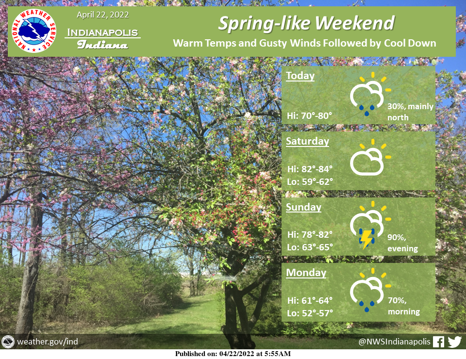
Spring-like weather will make a brief appearance this week with highs near 80!
Windy conditions may accompany the warmth, with gusts between 30 to 40 mph possible Saturday and Sunday.
A cold front is then expected to bring rain, a few storms, and cooler temps by Monday.
INDIANAPOLIS 7-DAY EXTENDED FORECAST
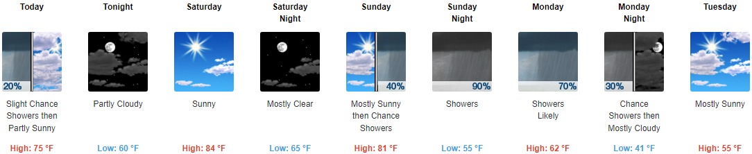
Today: A slight chance of showers between 9am and noon. Mostly cloudy, with a high near 75. Light east wind becoming southeast 5 to 10 mph in the morning. Winds could gust as high as 21 mph. Chance of precipitation is 20%.
Tonight: Partly cloudy, with a low around 60. South southeast wind around 10 mph.
Saturday: Sunny, with a high near 84. South southwest wind 8 to 17 mph, with gusts as high as 28 mph.
Saturday Night: Mostly clear, with a low around 65. South wind around 11 mph, with gusts as high as 22 mph.
Sunday: A chance of showers between 2pm and 5pm, then a chance of showers and thunderstorms after 5pm. Partly sunny, with a high near 81. South southwest wind 13 to 18 mph, with gusts as high as 31 mph. Chance of precipitation is 40%.
Sunday Night: A chance of showers and thunderstorms, then showers and possibly a thunderstorm after 8pm. Low around 55. Chance of precipitation is 90%. New rainfall amounts between a quarter and half of an inch possible.
Monday: Showers likely and possibly a thunderstorm. Cloudy, with a high near 62. Chance of precipitation is 70%.
Monday Night: A 30 percent chance of showers before 8pm. Mostly cloudy, with a low around 41.
Tuesday: Mostly sunny, with a high near 55.
Tuesday Night: Mostly clear, with a low around 35.
Wednesday: Sunny, with a high near 55.
Wednesday Night: Partly cloudy, with a low around 36.
Thursday: Mostly sunny, with a high near 60.
THE UNITED STATES OF AMERICA 3-DAY OUTLOOK


SOURCE: NWS Indianapolis.
Follow NWS Indianapolis on Twitter @NWSIndianapolis for the latest Indianapolis area weather news.