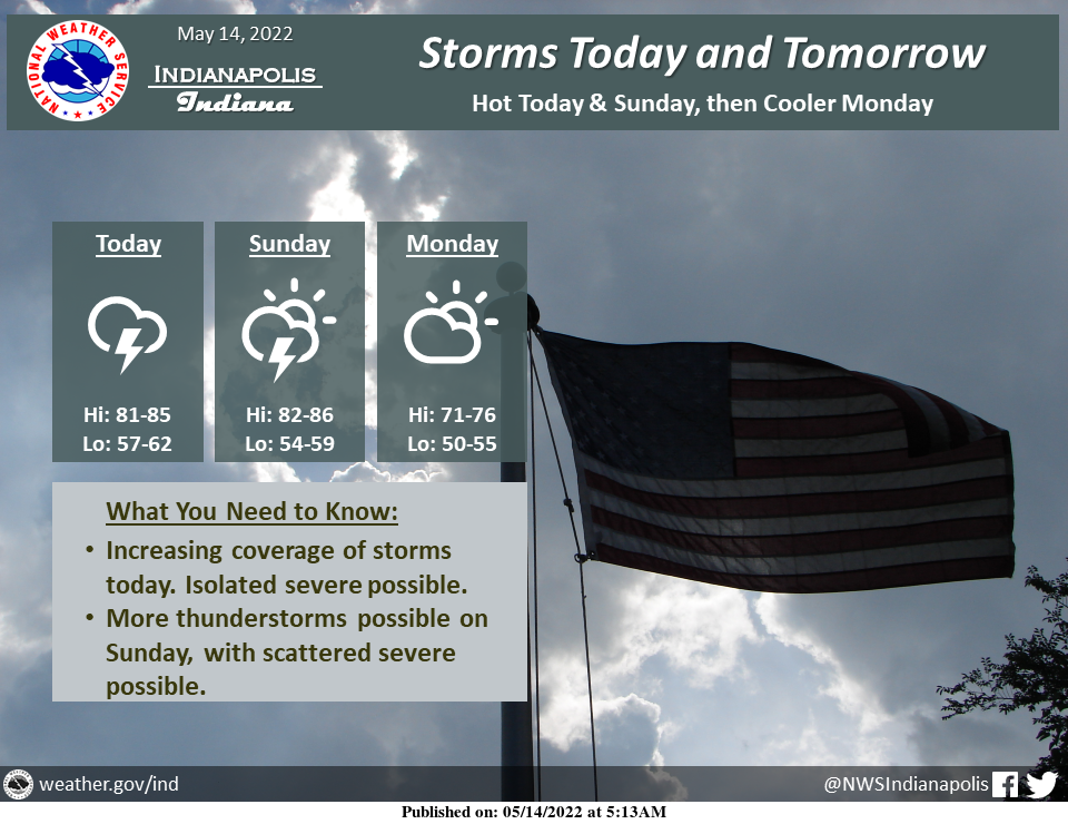
Showers and thunderstorms will increase in coverage today, with most areas seeing some rain today.
Storms will diminish this evening.
More scattered showers and thunderstorms will develop on Sunday.
Isolated severe storms are possible today into this evening, with scattered strong to severe storms possible on Sunday afternoon and night.
Hot conditions will continue through Sunday with highs in the lower to middle 80s.
Monday will be cooler with highs in the 70s. Lows will be in the 50s to around 60.
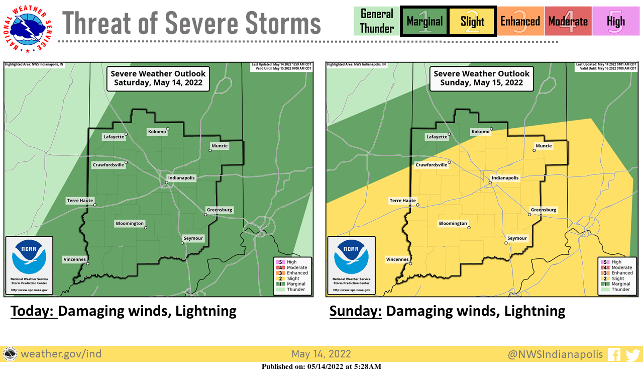
Active weather is expected for this weekend with isolated severe storms with damaging winds possible today.
Better chances for severe weather on Sunday with scattered severe storms possible, with damaging winds the primary threat. Be prepared to take action if outdoors!
INDIANAPOLIS 7-DAY EXTENDED FORECAST
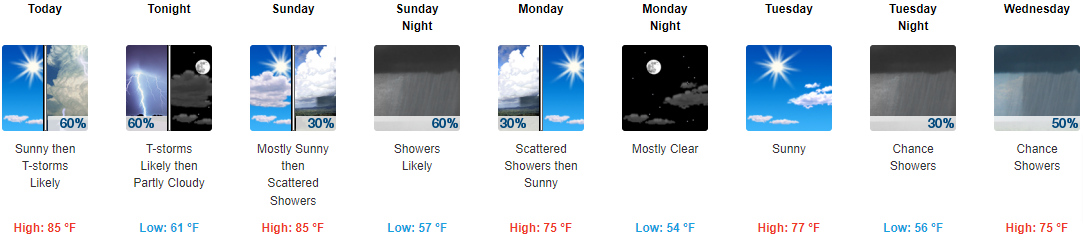
Today: A chance of showers and thunderstorms before 3pm, then showers likely and possibly a thunderstorm between 3pm and 5pm, then showers and thunderstorms likely after 5pm. Increasing clouds, with a high near 85. South southwest wind 3 to 6 mph. Chance of precipitation is 60%. New rainfall amounts between a tenth and quarter of an inch, except higher amounts possible in thunderstorms.
Tonight: Showers and thunderstorms likely, mainly before 10pm. Mostly cloudy, with a low around 61. West wind around 5 mph becoming calm in the evening. Chance of precipitation is 60%. New precipitation amounts of less than a tenth of an inch, except higher amounts possible in thunderstorms.
Sunday: Scattered showers and thunderstorms after 2pm. Mostly sunny, with a high near 85. Calm wind becoming west southwest 5 to 7 mph in the afternoon. Chance of precipitation is 30%.
Sunday Night: Scattered showers and thunderstorms before 8pm, then showers likely and possibly a thunderstorm between 8pm and 2am, then scattered showers and thunderstorms after 2am. Increasing clouds, with a low around 57. West wind 6 to 8 mph becoming north northwest after midnight. Chance of precipitation is 60%. New rainfall amounts between a tenth and quarter of an inch, except higher amounts possible in thunderstorms.
Monday: Scattered showers before 8am. Mostly sunny, with a high near 75. West northwest wind 6 to 13 mph, with gusts as high as 21 mph. Chance of precipitation is 30%.
Monday Night: Mostly clear, with a low around 54.
Tuesday: Sunny, with a high near 77.
Tuesday Night: A 30 percent chance of showers, mainly after 2am. Mostly cloudy, with a low around 56.
Wednesday: A chance of showers, with thunderstorms also possible after 2pm. Mostly cloudy, with a high near 75. Chance of precipitation is 50%.
Wednesday Night: A 50 percent chance of showers and thunderstorms. Mostly cloudy, with a low around 60.
Thursday: A 40 percent chance of showers and thunderstorms. Partly sunny, with a high near 80.
Thursday Night: A 30 percent chance of showers and thunderstorms. Partly cloudy, with a low around 64.
Friday: A 30 percent chance of showers and thunderstorms. Mostly sunny, with a high near 84.
THE UNITED STATES OF AMERICA 3-DAY OUTLOOK


SOURCE: NWS Indianapolis.
Follow NWS Indianapolis on Twitter @NWSIndianapolis for the latest Indianapolis area weather news.