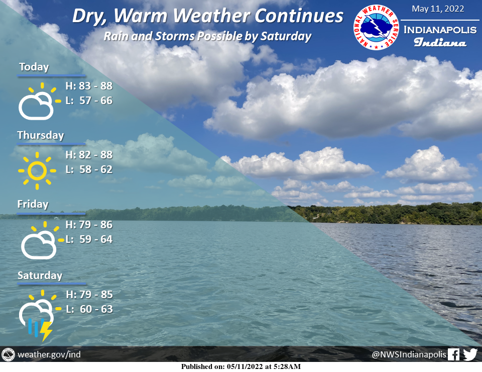
Dry weather with summer temperatures will continue through the remainder of the workweek.
Highs in the 80s are expected into Saturday.
As a frontal boundary moves across the area, increasing chances for showers and thunderstorms will develop Saturday and continue into Sunday.
INDIANAPOLIS 7-DAY EXTENDED FORECAST
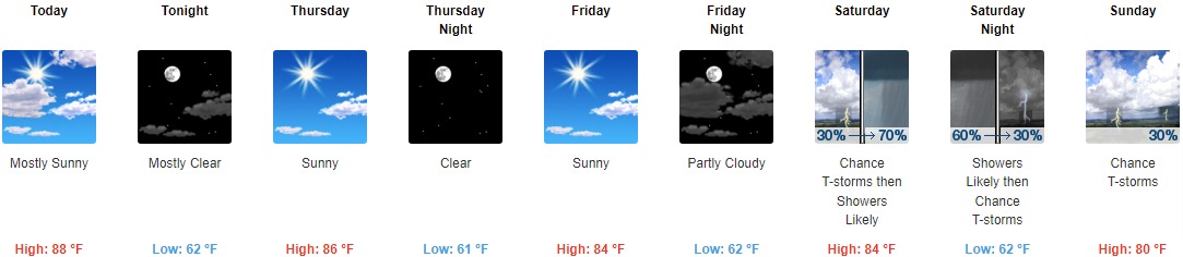
Today: Mostly sunny, with a high near 88. Southeast wind 3 to 7 mph.
Tonight: Mostly clear, with a low around 62. East southeast wind 5 to 7 mph.
Thursday: Sunny, with a high near 86. East southeast wind 6 to 9 mph.
Thursday Night: Clear, with a low around 61. East southeast wind around 7 mph.
Friday: Sunny, with a high near 84. South southeast wind 7 to 9 mph.
Friday Night: Partly cloudy, with a low around 62.
Saturday: There is a chance of showers and thunderstorms, then likely showers and possibly a thunderstorm after 2pm. Mostly sunny, with a high near 84. The chance of precipitation is 70%.
Saturday Night: Showers likely and possibly a thunderstorm before 8pm, then a chance of showers and thunderstorms between 8pm and 2am. Partly cloudy, with a low around 62. The chance of precipitation is 60%.
Sunday: There is a 30 percent chance of showers and thunderstorms, mainly after 2pm. Mostly sunny, with a high near 80.
Sunday Night: There is a 30 percent chance of showers and thunderstorms, mainly before 8pm. Partly cloudy, with a low around 58.
Monday: Sunny, with a high near 79.
Monday Night: A 20 percent chance of showers. Partly cloudy, with a low around 58.
Tuesday: A 30 percent chance of showers and thunderstorms. Mostly sunny, with a high near 78.
THE UNITED STATES OF AMERICA 3-DAY OUTLOOK


SOURCE: NWS Indianapolis.
Follow NWS Indianapolis on Twitter @NWSIndianapolis for the latest Indianapolis area weather news.