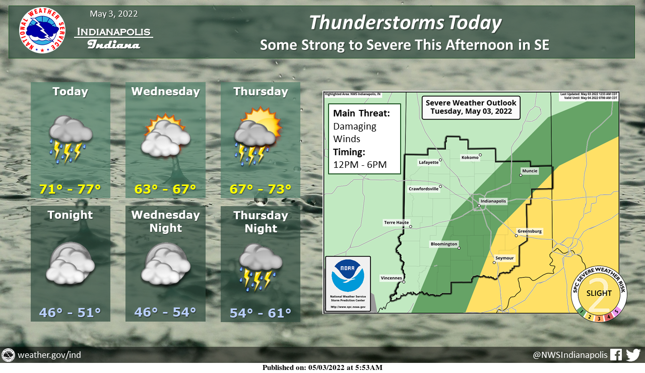
Expect rain and thunderstorms throughout the day today.
Some storms over the SE may be strong to severe this afternoon, with damaging winds being the main threat.
Tomorrow will be dry followed by a return of storms Thursday.
INDIANAPOLIS 7-DAY EXTENDED FORECAST
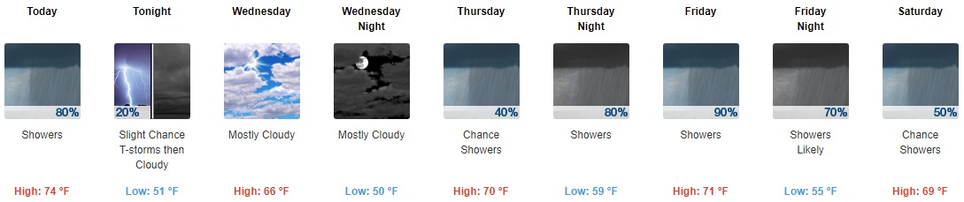
Today: Showers and thunderstorms before 3pm, then showers likely and possibly a thunderstorm between 3pm and 4pm, then a chance of showers and thunderstorms after 4pm. High near 74. South southeast wind 11 to 16 mph becoming southwest in the afternoon. Winds could gust as high as 29 mph. The chance of precipitation is 90%. New rainfall amounts between a quarter and half of an inch possible.
Tonight: A 30 percent chance of showers and thunderstorms, mainly before 9pm. Mostly cloudy, with a low around 51. West wind 8 to 14 mph, with gusts as high as 23 mph.
Wednesday: Mostly cloudy, with a high near 66. North wind 6 to 8 mph.
Wednesday Night: Mostly cloudy, with a low around 50. Northeast wind around 5 mph.
Thursday: A 40 percent chance of showers, mainly after 3pm. Mostly cloudy, with a high near 70. East wind 6 to 9 mph, with gusts as high as 20 mph.
Thursday Night: A chance of showers, then showers, and possibly a thunderstorm after 9pm. Low around 59. The chance of precipitation is 80%. New rainfall amounts between a quarter and half of an inch possible.
Friday: Showers and possibly a thunderstorm. High near 71. The chance of precipitation is 90%.
Friday Night: Showers and possibly a thunderstorm before 3am, then a chance of showers. Low around 55. The chance of precipitation is 90%.
Saturday: A 50 percent chance of showers. Mostly cloudy, with a high near 69.
Saturday Night: A 40 percent chance of showers, mainly before 9pm. Mostly cloudy, with a low around 53.
Sunday: Partly sunny, with a high near 74.
Sunday Night: Partly cloudy, with a low around 58.
Monday: Sunny, with a high near 81.
THE UNITED STATES OF AMERICA 3-DAY OUTLOOK


SOURCE: NWS Indianapolis.
Follow NWS Indianapolis on Twitter @NWSIndianapolis for the latest Indianapolis area weather news.