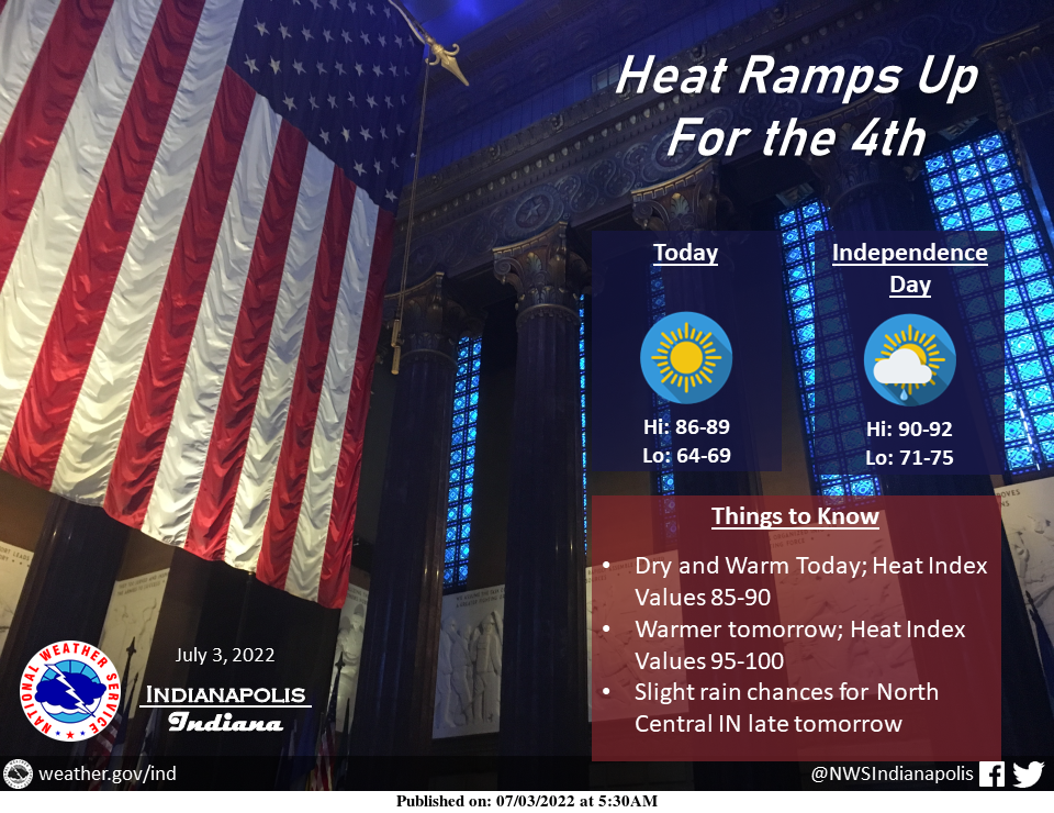
Sunshine returns today with highs in the upper 80s.
Dew points near 60 will feel relatively pleasant compared to tomorrow as temperatures exceed 90 and dew points push up into the low 70s.
This will result in heat index values near 100 tomorrow afternoon.
A system will approach from the NW late tomorrow, providing slight chances of rain.
INDIANAPOLIS 7-DAY EXTENDED FORECAST
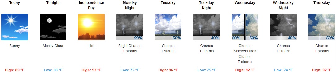
Today: Sunny, with a high near 89. East wind around 7 mph.
Tonight: Mostly clear, with a low around 68. East wind 5 to 7 mph becoming calm in the evening.
Independence Day: Mostly sunny and hot, with a high near 93. Southeast wind 3 to 8 mph.
Monday Night: A 20 percent chance of showers and thunderstorms. Partly cloudy, with a low around 75. South southwest wind 5 to 8 mph.
Tuesday: A 50 percent chance of showers and thunderstorms. Mostly sunny and hot, with a high near 96. West southwest wind 6 to 10 mph, with gusts as high as 20 mph. New rainfall amounts between a tenth and quarter of an inch, except higher amounts possible in thunderstorms.
Tuesday Night: A 40 percent chance of showers and thunderstorms. Partly cloudy, with a low around 75.
Wednesday: A 50 percent chance of showers and thunderstorms. Mostly sunny and hot, with a high near 92.
Wednesday Night: A 40 percent chance of showers and thunderstorms. Mostly cloudy, with a low around 74.
Thursday: A 50 percent chance of showers and thunderstorms. Partly sunny and hot, with a high near 92.
Thursday Night: A 40 percent chance of showers and thunderstorms. Mostly cloudy, with a low around 73.
Friday: A 50 percent chance of showers and thunderstorms. Partly sunny, with a high near 88.
Friday Night: A 30 percent chance of showers. Partly cloudy, with a low around 68.
Saturday: A 20 percent chance of showers. Mostly sunny, with a high near 82.
THE UNITED STATES OF AMERICA 3-DAY OUTLOOK


SOURCE: NWS Indianapolis.
Follow NWS Indianapolis on Twitter @NWSIndianapolis for the latest Indianapolis area weather news.