
Patchy fog has developed over the past few hours, but expect it to quickly dissipate by mid-morning.
Look for warm and dry conditions with increasing clouds throughout the day.
INDIANAPOLIS 7-DAY EXTENDED FORECAST
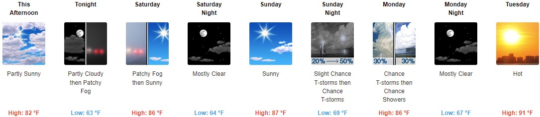
This Afternoon: Partly sunny, with a steady temperature around 82. South wind around 7 mph.
Tonight: Patchy fog after 4am. Otherwise, partly cloudy, with a low of around 63. Southeast wind 5 to 7 mph becoming calm in the evening.
Saturday: Patchy fog before 9am. Otherwise, sunny, with a high near 86. Light south southeast wind becoming south southwest 5 to 10 mph in the morning.
Saturday Night: Mostly clear, with a low around 64. South wind around 7 mph.
Sunday: Sunny, with a high near 87. Southwest wind 5 to 11 mph, with gusts as high as 21 mph.
Sunday Night: A 50 percent chance of showers and thunderstorms, mainly after 2am. Partly cloudy, with a low around 69. New rainfall amounts between a tenth and quarter of an inch, except higher amounts possible in thunderstorms.
Monday: A 30 percent chance of showers and thunderstorms before 2pm. Partly sunny, with a high near 86.
Monday Night: Mostly clear, with a low of around 67.
Tuesday: Sunny and hot, with a high near 91.
Tuesday Night: Mostly clear, with a low around 70.
Wednesday: Sunny and hot, with a high near 92.
Wednesday Night: Partly cloudy, with a low around 69.
Thursday: Mostly sunny, with a high near 86.
THE UNITED STATES OF AMERICA 3-DAY OUTLOOK


SOURCE: NWS Indianapolis.
Follow NWS Indianapolis on Twitter @NWSIndianapolis for the latest Indianapolis area weather news.