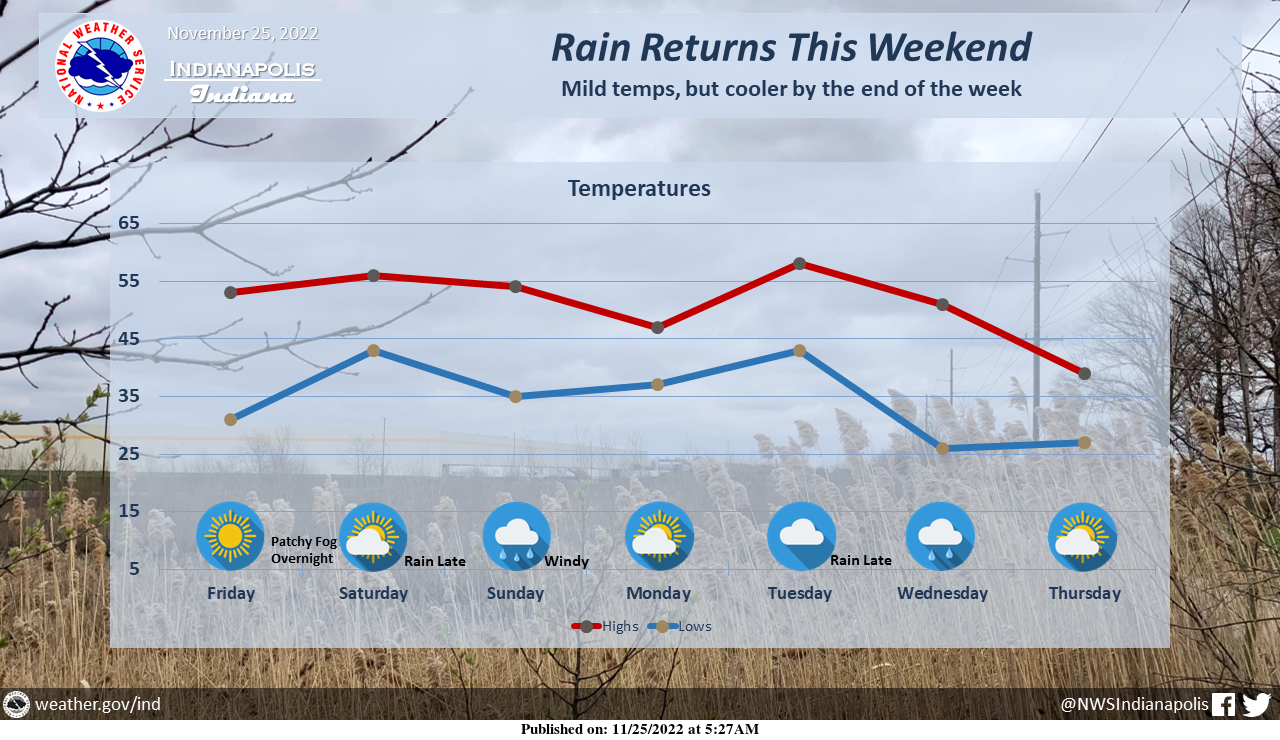
Sunshine will make an appearance today and tomorrow, but more rain is on the way by Sunday.
In addition to the rain, winds may be gusty at times on Sunday as well.
After a quick break, another round of rain is possible late Tuesday into Wednesday!
INDIANAPOLIS 7-DAY EXTENDED FORECAST
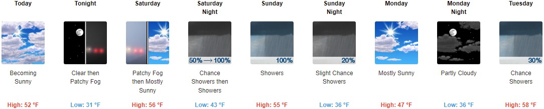
Today: Mostly cloudy early, then gradual clearing, with a high near 52. North northwest wind around 8 mph.
Tonight: Patchy fog after 3am. Otherwise, mostly clear, with a low around 31. West northwest wind around 5 mph becoming light and variable in the evening.
Saturday: Patchy fog before 7am. Otherwise, mostly sunny, with a high near 56. Calm wind becoming south around 6 mph in the afternoon.
Saturday Night: Showers, mainly after 1am. Low around 43. Southeast wind 7 to 9 mph, with gusts as high as 18 mph. The chance of precipitation is 100%. New precipitation amounts between a half and three-quarters of an inch possible.
Sunday: Showers, mainly before 1pm. High near 55. South-southeast wind 10 to 15 mph becoming west in the afternoon. Winds could gust as high as 34 mph. The chance of precipitation is 100%. New precipitation amounts between a quarter and half of an inch possible.
Sunday Night: A 20 percent chance of showers before 1am. Mostly cloudy, with a low of around 36.
Monday: Mostly sunny, with a high near 47.
Monday Night: Partly cloudy, with a low around 36.
Tuesday: A 30 percent chance of showers, mainly after 1pm. Mostly cloudy, with a high near 58.
Tuesday Night: Showers. Low around 44. The chance of precipitation is 80%.
Wednesday: A 40 percent chance of showers. Partly sunny, with a high near 52.
Wednesday Night: A 20 percent chance of snow showers. Partly cloudy, with a low of around 27.
Thursday: Sunny, with a high near 39.
THE UNITED STATES OF AMERICA 3-DAY OUTLOOK


SOURCE: NWS Indianapolis.
Follow NWS Indianapolis on Twitter @NWSIndianapolis for the latest Indianapolis area weather news.