Periodic flurries and light snow showers through Friday.
Warmer Saturday with a low chance of rain showers.
INDIANAPOLIS 7-DAY EXTENDED FORECAST
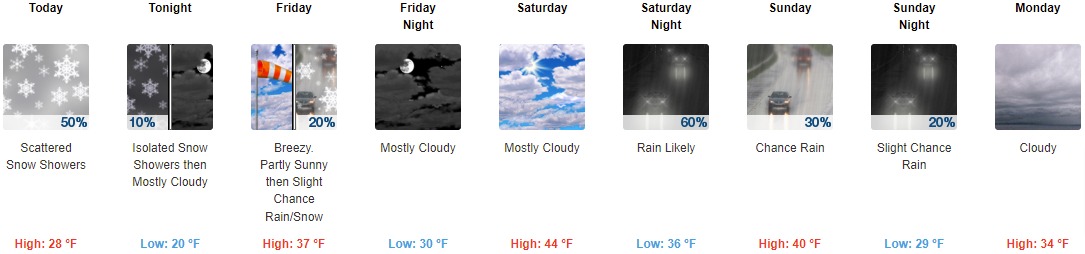
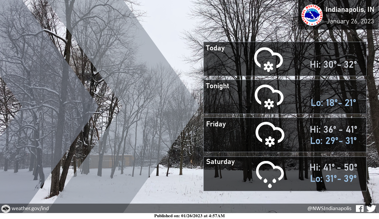
Today: Scattered snow showers, mainly before 5pm. Cloudy, with a steady temperature around 28. West-southwest wind around 15 mph, with gusts as high as 25 mph. The chance of precipitation is 50%.
Tonight: Scattered flurries with isolated snow showers before 7pm, then scattered flurries between 7pm and 1am. Cloudy, then gradually becoming partly cloudy, with a low of around 20. West southwest wind 11 to 15 mph, with gusts as high as 22 mph. The chance of precipitation is 10%.
Friday: A slight chance of snow between 1pm and 4pm, then a slight chance of rain after 4pm. Increasing clouds, with a high near 37. Breezy, with a south wind 13 to 22 mph, with gusts as high as 34 mph. The chance of precipitation is 20%.
Friday Night: Mostly cloudy, with a low of around 30. Southwest wind 9 to 18 mph, with gusts as high as 29 mph.
Saturday: Mostly cloudy, with a high near 44. South wind 7 to 14 mph, with gusts as high as 21 mph.
Saturday Night: Rain likely, mainly before 1am. Cloudy, with a low of around 36. The chance of precipitation is 60%. New precipitation amounts of less than a tenth of an inch possible.
Sunday: A 30 percent chance of rain. Cloudy, with a high near 40.
Sunday Night: A 20 percent chance of rain before 1am. Cloudy, with a low of around 29.
Monday: Cloudy, with a high near 34.
Monday Night: A 40 percent chance of snow after 1am. Mostly cloudy, with a low of around 22.
Tuesday: A 40 percent chance of snow. Partly sunny, with a high near 29.
Tuesday Night: A 50 percent chance of snow. Mostly cloudy, with a low around 21.
Wednesday: A 20 percent chance of snow. Mostly cloudy, with a high near 26.
THE UNITED STATES OF AMERICA 3-DAY OUTLOOK


SOURCE: NWS Indianapolis.
Follow NWS Indianapolis on Twitter @NWSIndianapolis for the latest Indianapolis area weather news.