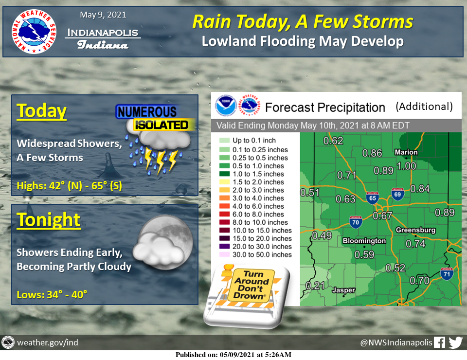
Widespread rain is expected much of today with a few thunderstorms, some of which could be strong, primarily south.
An additional inch of rain is possible, with the highest amounts expected central and northeast.
Lowland flooding may develop along some streams and rivers over the next 48 hours.
Showers will quickly end this evening with skies becoming partly cloudy.
INDIANAPOLIS 7-DAY EXTENDED FORECAST
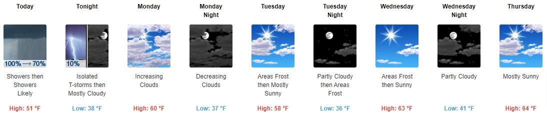
Today: Showers and possibly a thunderstorm before 2 pm, then scattered showers and thunderstorms, mainly between 2 pm and 4 pm. High near 51. East wind 8 to 13 mph becoming north in the afternoon. Winds could gust as high as 23 mph. The chance of precipitation is 100%. New rainfall amounts between a half and three-quarters of an inch possible.
Tonight: Isolated showers and thunderstorms before 7 pm. Cloudy, then gradually becoming partly cloudy, with a low around 38. North northeast wind 5 to 14 mph, with gusts as high as 24 mph. The chance of precipitation is 10%.
Monday: Increasing clouds, with a high near 60. Calm wind becoming north around 6 mph in the morning.
Monday Night: Mostly cloudy, then gradually becoming mostly clear, with a low around 37. North wind around 6 mph.
Tuesday: Areas of frost before 8 am. Otherwise, mostly sunny, with a high near 58. Light north wind increasing to 5 to 10 mph in the morning.
Tuesday Night: Areas of frost after 4 am. Otherwise, mostly clear, with a low around 36.
Wednesday: Areas of frost before 8 am. Otherwise, sunny, with a high near 63.
Wednesday Night: Partly cloudy, with a low around 41.
Thursday: Mostly sunny, with a high near 64.
Thursday Night: Partly cloudy, with a low around 43.
Friday: Sunny, with a high near 68.
Friday Night: A 20 percent chance of showers. Partly cloudy, with a low around 50.
Saturday: A 30 percent chance of showers. Mostly sunny, with a high near 71.
THE UNITED STATES OF AMERICA 3-DAY OUTLOOK


SOURCE: NWS Indianapolis.
Follow NWS Indianapolis on Twitter @NWSIndianapolis for the latest Indianapolis area weather news.