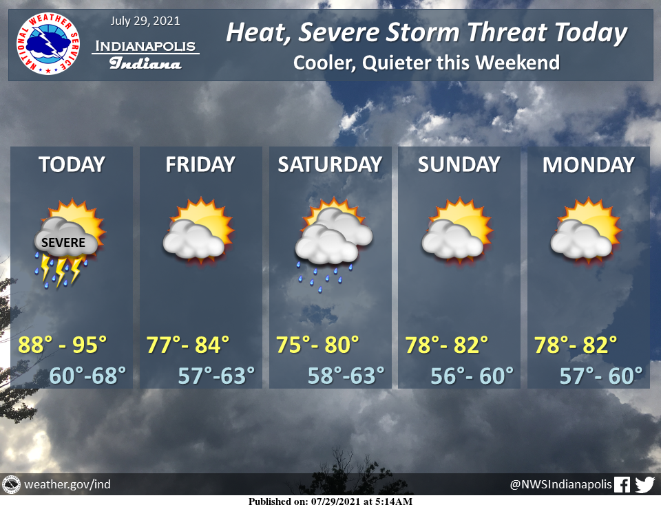
It will be hot today with heat indices above 100 for much of the area.
Strong to severe storms will be possible today with the main threat being damaging winds, but all hazards are possible.
Temperatures will cool down going into the weekend.
IT'S GOING TO BE FREAKING HOT
The heat index will be near or above 100 degrees at times this afternoon over central Indiana.
A heat advisory is in effect for western and southern Indiana where heat indices could range from 105 to 112 at times.
Wear light colors, limit outdoor exposure, and stay hydrated!
INDIANAPOLIS 7-DAY EXTENDED FORECAST
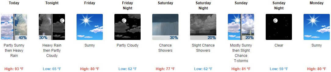
Today: A 40 percent chance of showers and thunderstorms after 2pm. Some of the storms could produce heavy rainfall. Partly sunny and hot, with a high near 93. Heat index values as high as 102. West southwest wind 8 to 14 mph, with gusts as high as 22 mph.
Tonight: A 30 percent chance of showers and thunderstorms, mainly before 9pm. Some of the storms could produce heavy rainfall. Partly cloudy, with a low around 65. North wind 6 to 9 mph.
Friday: Sunny, with a high near 80. North wind around 8 mph.
Friday Night: Partly cloudy, with a low around 62. North northeast wind 5 to 7 mph.
Saturday: A 30 percent chance of showers. Partly sunny, with a high near 77. Light and variable wind becoming south around 5 mph in the afternoon.
Saturday Night: A 20 percent chance of showers before 2am. Partly cloudy, with a low around 62.
Sunday: A 20 percent chance of showers and thunderstorms after 2pm. Mostly sunny, with a high near 81.
Sunday Night: Clear, with a low around 59.
Monday: Sunny, with a high near 80.
Monday Night: Mostly clear, with a low around 59.
Tuesday: Sunny, with a high near 81.
Tuesday Night: Mostly clear, with a low around 61.
Wednesday: Sunny, with a high near 84.
THE UNITED STATES OF AMERICA 3-DAY OUTLOOK


SOURCE: NWS Indianapolis.
Follow NWS Indianapolis on Twitter @NWSIndianapolis for the latest Indianapolis area weather news.