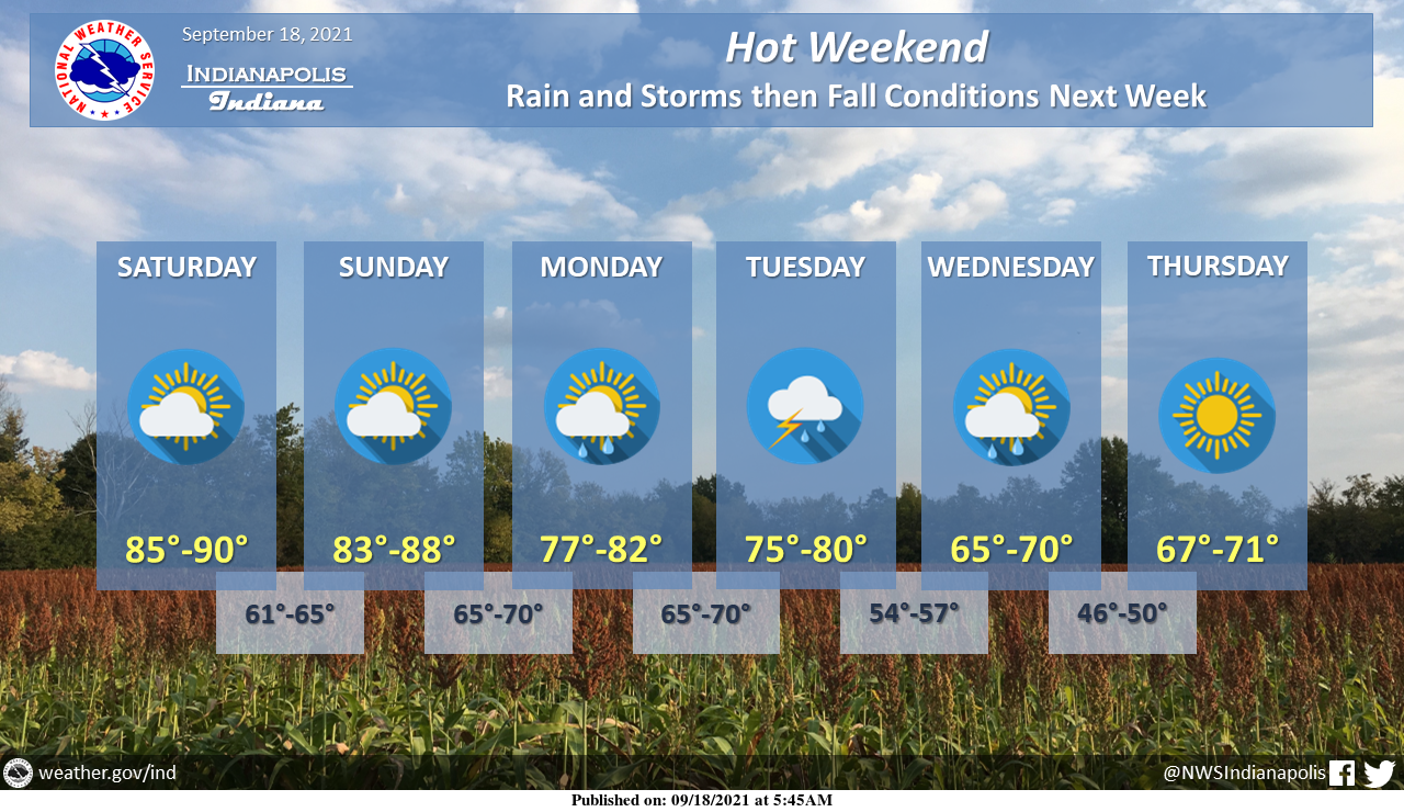
It'll be another hot weekend but some fall weather is finally on the horizon!
Chances for rain and thunderstorms will exist from Sunday night into Wednesday, with the best chances for storms on Tuesday.
INDIANAPOLIS 7-DAY EXTENDED FORECAST
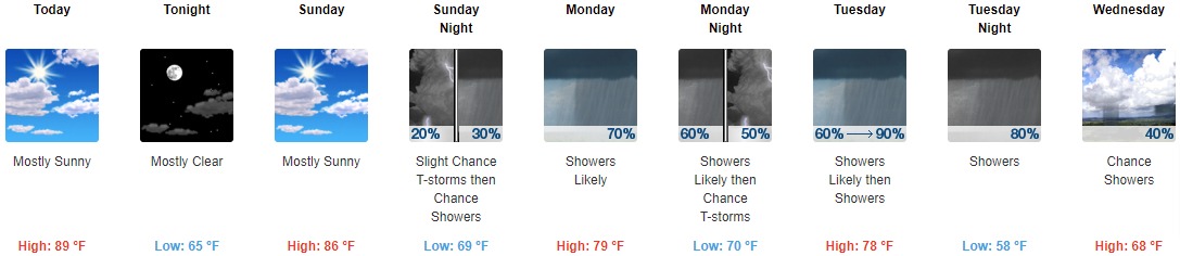
Today: Mostly sunny, with a high near 89. Light and variable wind.
Tonight: Mostly clear, with a low around 65. Light east wind.
Sunday: Mostly sunny, with a high near 86. Southeast wind 5 to 8 mph.
Sunday Night: A slight chance of showers, then a chance of showers and thunderstorms after 11pm. Mostly cloudy, with a low around 69. East southeast wind around 7 mph. The chance of precipitation is 30%.
Monday: A chance of showers and thunderstorms, then showers likely and possibly a thunderstorm after 2pm. Mostly cloudy, with a high near 79. South wind 8 to 11 mph, with gusts as high as 21 mph. The chance of precipitation is 70%. New rainfall amounts between a tenth and quarter of an inch, except higher amounts possible in thunderstorms.
Monday Night: Showers likely and possibly a thunderstorm before 8pm, then a chance of showers and thunderstorms after 8pm. Mostly cloudy, with a low around 70. The chance of precipitation is 60%. New rainfall amounts of less than a tenth of an inch, except higher amounts possible in thunderstorms.
Tuesday: Showers and possibly a thunderstorm. High near 78. The chance of precipitation is 90%.
Tuesday Night: Showers and possibly a thunderstorm before 2am, then a chance of showers. Low around 58. The chance of precipitation is 80%.
Wednesday: A 40 percent chance of showers. Mostly sunny, with a high near 68.
Wednesday Night: Partly cloudy, with a low around 50.
Thursday: Sunny, with a high near 69.
Thursday Night: Mostly clear, with a low around 49.
Friday: Sunny, with a high near 73.
THE UNITED STATES OF AMERICA 3-DAY OUTLOOK


SOURCE: NWS Indianapolis.
Follow NWS Indianapolis on Twitter @NWSIndianapolis for the latest Indianapolis area weather news.