
Dry and cold with patchy overnight frost.
The only exception will be low chances for some isolated rain showers across the southern counties this evening.
INDIANAPOLIS 7-DAY EXTENDED FORECAST
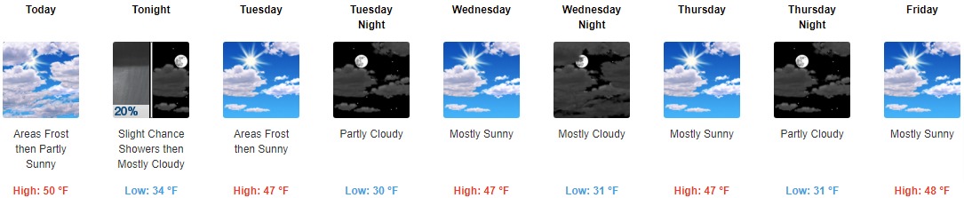
Today: Areas of frost before 11am. Otherwise, partly sunny, with a high near 50. Calm wind becoming west northwest around 6 mph in the afternoon.
Tonight: A slight chance of showers between 10pm and midnight. Cloudy, then gradually becoming partly cloudy, with a low around 34. West northwest wind around 5 mph becoming calm in the evening. Chance of precipitation is 20%.
Tuesday: Areas of frost before 9am. Otherwise, mostly sunny, with a high near 47. Light west northwest wind increasing to 5 to 10 mph in the afternoon.
Tuesday Night: Partly cloudy, with a low around 30. West northwest wind around 6 mph becoming calm in the evening.
Wednesday: Mostly sunny, with a high near 47. Light north northwest wind.
Wednesday Night: Mostly cloudy, with a low around 31.
Thursday: Mostly sunny, with a high near 47.
Thursday Night: Partly cloudy, with a low around 31.
Friday: Mostly sunny, with a high near 48.
Friday Night: Partly cloudy, with a low around 33.
Saturday: Mostly sunny, with a high near 52.
Saturday Night: Partly cloudy, with a low around 36.
Sunday: Partly sunny, with a high near 52.
THE UNITED STATES OF AMERICA 3-DAY OUTLOOK


SOURCE: NWS Indianapolis.
Follow NWS Indianapolis on Twitter @NWSIndianapolis for the latest Indianapolis area weather news.