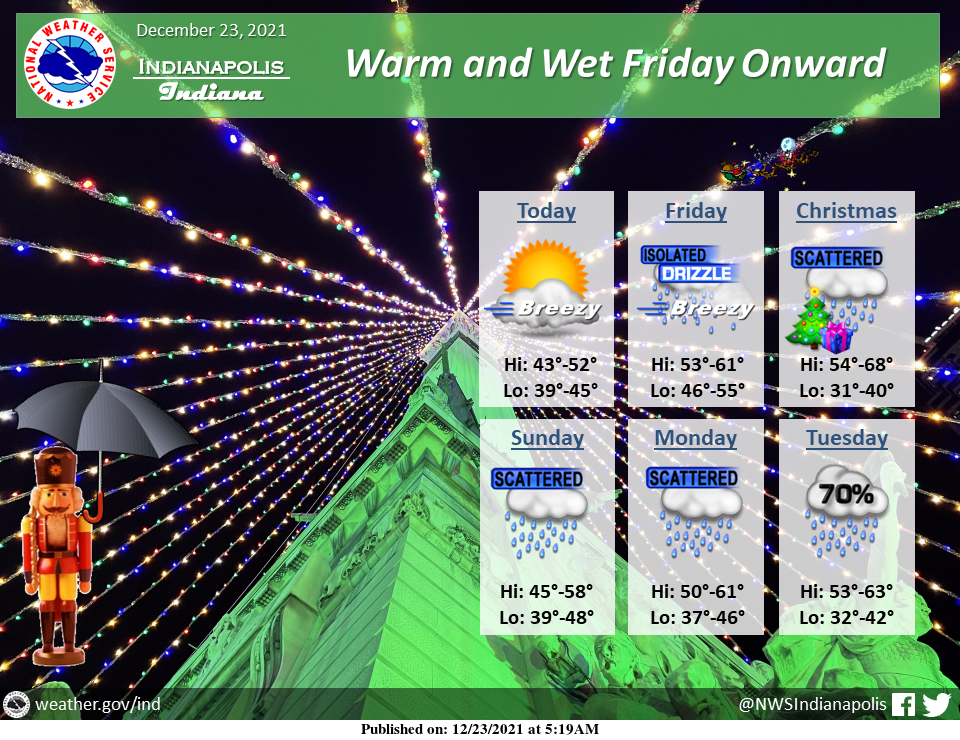
Breezy conditions and increasing clouds can be expected today.
The weather will turn warm and wet for the holiday weekend into next week, with temperatures well above normal and frequent opportunities for rainfall.
INDIANAPOLIS 7-DAY EXTENDED FORECAST
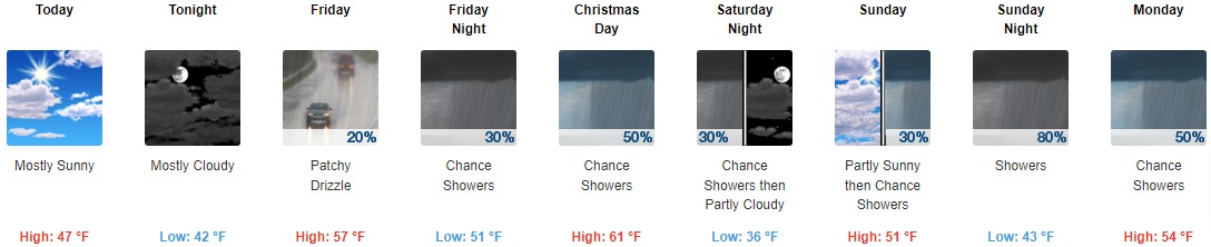
Today: Mostly sunny, with a high near 47. South southwest wind 9 to 15 mph, with gusts as high as 26 mph.
Tonight: Mostly cloudy, with a low around 42. Southwest wind 8 to 13 mph, with gusts as high as 24 mph.
Friday: Patchy drizzle with isolated showers after 8am. Cloudy, with a high near 57. South wind 9 to 14 mph, with gusts as high as 26 mph. The chance of precipitation is 20%.
Friday Night: Patchy drizzle with isolated showers before 8pm, then a chance of showers, mainly after 2am. Mostly cloudy, with a low around 51. South southwest wind 8 to 14 mph, with gusts as high as 25 mph. The chance of precipitation is 30%.
Christmas Day: A 50 percent chance of showers. Mostly cloudy, with a high near 61. Southwest wind 7 to 10 mph becoming west northwest in the afternoon. Winds could gust as high as 21 mph. New precipitation amounts between a tenth and a quarter of an inch possible.
Saturday Night: A 30 percent chance of showers before 8pm. Mostly cloudy, with a low around 36.
Sunday: A 30 percent chance of showers after 2pm. Partly sunny, with a high near 51.
Sunday Night: Showers, mainly between 8pm and 2am. Low around 43. The chance of precipitation is 80%.
Monday: A 50 percent chance of showers, mainly after 2pm. Mostly cloudy, with a high near 54.
Monday Night: A 50 percent chance of showers. Mostly cloudy, with a low around 41.
Tuesday: Showers likely. Mostly cloudy, with a high near 57. The chance of precipitation is 60%.
Tuesday Night: Showers likely. Mostly cloudy, with a low around 38. The chance of precipitation is 60%.
Wednesday: A 30 percent chance of showers. Partly sunny, with a high near 47.
THE UNITED STATES OF AMERICA 3-DAY OUTLOOK


SOURCE: NWS Indianapolis.
Follow NWS Indianapolis on Twitter @NWSIndianapolis for the latest Indianapolis area weather news.