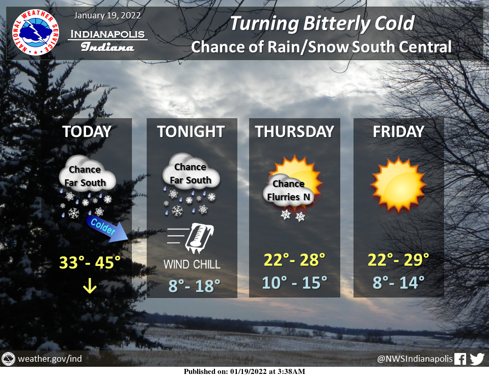
Temperatures will be dropping today from northwest to southeast as a cold front moves through.
Wind chills tonight will drop as low as 5 degrees below zero over northwestern sections with single-digit overnight wind chills elsewhere.
There is a chance for precipitation with rain changing to snow across areas near and south of a Rushville to Edinburgh to Sullivan line this afternoon and tonight and a chance of flurries over northeastern sections Thursday.
Otherwise, dry and cold weather will be featured the rest of the week with afternoon highs in the 20s and overnight lows in the teens.
INDIANAPOLIS 7-DAY EXTENDED FORECAST
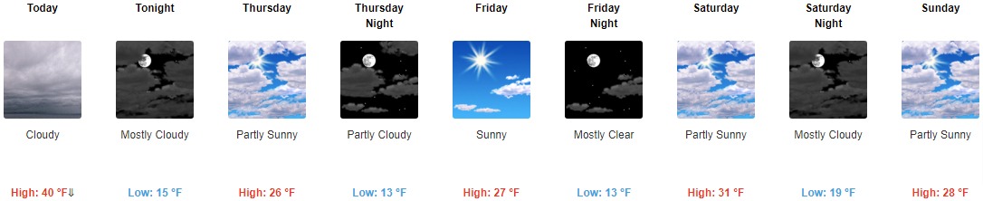
Today: Cloudy, with a temperature falling to around 33 by 5pm. West southwest wind 7 to 11 mph becoming northwest in the afternoon. Winds could gust as high as 18 mph.
Tonight: Mostly cloudy, with a low around 15. North wind 11 to 13 mph, with gusts as high as 21 mph.
Thursday: Partly sunny, with a high near 26. North wind around 10 mph.
Thursday Night: Partly cloudy, with a low around 13. North wind 5 to 8 mph.
Friday: Sunny, with a high near 27. East northeast wind 3 to 6 mph.
Friday Night: Mostly clear, with a low around 13.
Saturday: Mostly sunny, with a high near 31.
Saturday Night: Mostly cloudy, with a low around 19.
Sunday: Partly sunny, with a high near 28.
Sunday Night: Mostly cloudy, with a low around 18.
Monday: Partly sunny, with a high near 30.
Monday Night: Mostly cloudy, with a low around 18.
Tuesday: Partly sunny, with a high near 28.
THE UNITED STATES OF AMERICA 3-DAY OUTLOOK


SOURCE: NWS Indianapolis.
Follow NWS Indianapolis on Twitter @NWSIndianapolis for the latest Indianapolis area weather news.