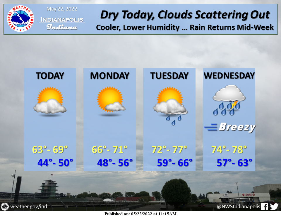
Conditions will remain dry and cool until Tuesday night when chances for rain return to the region.
INDIANAPOLIS 7-DAY EXTENDED FORECAST
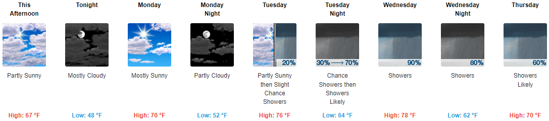
This Afternoon: Partly sunny, with a high near 67. North northwest wind around 10 mph, with gusts as high as 18 mph.
Tonight: Mostly cloudy, with a low around 48. North northeast wind 5 to 8 mph.
Monday: Mostly sunny, with a high near 70. East northeast wind 6 to 9 mph.
Monday Night: Partly cloudy, with a low around 52. East northeast wind 6 to 8 mph.
Tuesday: A 20 percent chance of showers after 2pm. Partly sunny, with a high near 76. East wind 6 to 8 mph.
Tuesday Night: A chance of showers and thunderstorms before 2am, then showers likely between 2am and 5am, then showers likely and possibly a thunderstorm after 5am. Mostly cloudy, with a low around 64. The chance of precipitation is 70%. New rainfall amounts between a tenth and quarter of an inch, except higher amounts possible in thunderstorms.
Wednesday: Showers and possibly a thunderstorm. High near 78. The chance of precipitation is 90%.
Wednesday Night: Showers and possibly a thunderstorm. Low around 62. The chance of precipitation is 80%.
Thursday: Showers likely, with thunderstorms also possible after 2pm. Mostly cloudy, with a high near 70. The chance of precipitation is 60%.
Thursday Night: A chance of showers and thunderstorms. Mostly cloudy, with a low around 54. The chance of precipitation is 40%.
Friday: A 30 percent chance of showers. Mostly sunny, with a high near 72.
Friday Night: A 20 percent chance of showers. Partly cloudy, with a low around 57.
Saturday: A 20 percent chance of showers and thunderstorms. Sunny, with a high near 80.
THE UNITED STATES OF AMERICA 3-DAY OUTLOOK


SOURCE: NWS Indianapolis.
Follow NWS Indianapolis on Twitter @NWSIndianapolis for the latest Indianapolis area weather news.