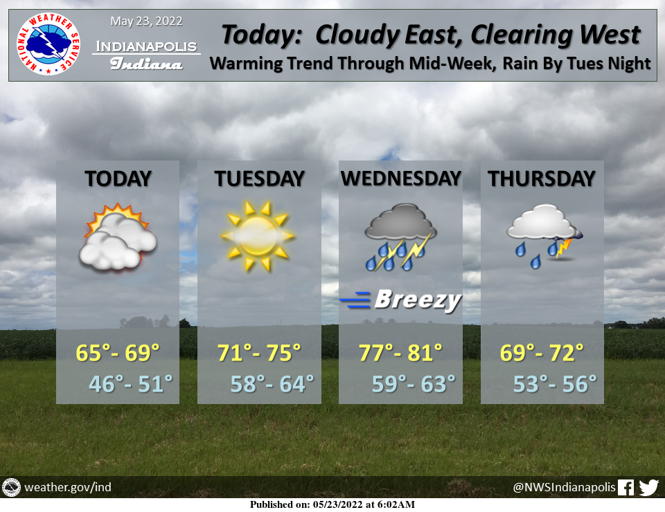
Dry, yet cool today under considerable cloudiness that should scatter out by late day. Pleasant Tuesday under thickening clouds before rain and thunderstorms return by late Tuesday night. #
INDIANAPOLIS 7-DAY EXTENDED FORECAST

Today: Partly sunny, with a high near 68. Northeast wind around 10 mph, with gusts as high as 18 mph.
Tonight: Mostly clear, with a low around 49. East northeast wind 6 to 9 mph.
Tuesday: Mostly sunny, with a high near 75. East northeast wind 6 to 8 mph.
Tuesday Night: A slight chance of showers between 9pm and 3am, then a chance of showers and thunderstorms after 3am. Mostly cloudy, with a low around 62. East wind around 8 mph. Chance of precipitation is 50%. New rainfall amounts of less than a tenth of an inch, except higher amounts possible in thunderstorms.
Wednesday: A chance of showers and thunderstorms, then showers and possibly a thunderstorm after 9am. High near 80. South wind 9 to 14 mph, with gusts as high as 26 mph. Chance of precipitation is 80%. New rainfall amounts between a quarter and half of an inch possible.
Wednesday Night: Showers and possibly a thunderstorm. Low around 63. Chance of precipitation is 80%. New rainfall amounts between a quarter and half of an inch possible.
Thursday: Showers likely and possibly a thunderstorm before 9am, then a chance of showers. Mostly cloudy, with a high near 72. Chance of precipitation is 70%.
Thursday Night: A 40 percent chance of showers, mainly before 3am. Mostly cloudy, with a low around 56.
Friday: A 20 percent chance of showers before 3pm. Mostly sunny, with a high near 74.
Friday Night: Mostly clear, with a low around 58.
Saturday: Sunny, with a high near 80.
Saturday Night: Partly cloudy, with a low around 64.
Sunday: Sunny, with a high near 86.
THE UNITED STATES OF AMERICA 3-DAY OUTLOOK


SOURCE: NWS Indianapolis.
Follow NWS Indianapolis on Twitter @NWSIndianapolis for the latest Indianapolis area weather news.