
Have you noticed the beautiful sunsets here in Indiana the past few days?
Thanks to high cirrus clouds, light scatters into the pretty pinks and vivid oranges we have seen, and this should continue into the weekend before a cold front brings a chance of thunderstorms on Sunday.
INDIANAPOLIS 7-DAY EXTENDED FORECAST
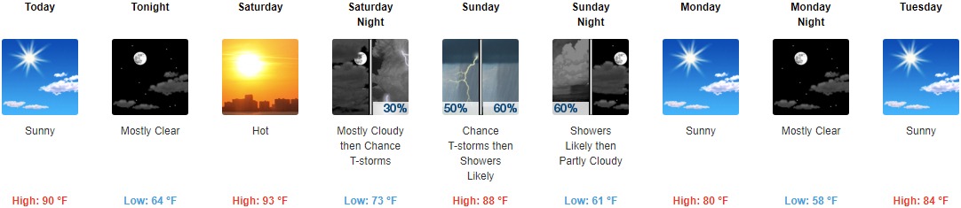
Today: Sunny, with a high near 90. Light south southeast wind.
Tonight: Mostly clear, with a low around 64. East southeast wind around 5 mph becoming calm in the evening.
Saturday: Mostly sunny and hot, with a high near 93. Calm wind becoming south southwest around 6 mph in the morning.
Saturday Night: A 30 percent chance of showers and thunderstorms after 2am. Mostly cloudy, with a low around 73. South wind 3 to 6 mph.
Sunday: A chance of showers and thunderstorms, then showers likely and possibly a thunderstorm after 2pm. Mostly cloudy, with a high near 88. Southwest wind 5 to 9 mph becoming west northwest in the afternoon. The chance of precipitation is 60%. New rainfall amounts of less than a tenth of an inch, except higher amounts possible in thunderstorms.
Sunday Night: Showers likely before 8pm. Partly cloudy, with a low around 61. The chance of precipitation is 60%. New precipitation amounts of less than a tenth of an inch are possible.
Monday: Sunny, with a high near 80.
Monday Night: Mostly clear, with a low around 58.
Tuesday: Sunny, with a high near 84.
Tuesday Night: Clear, with a low around 60.
Wednesday: Sunny, with a high near 88.
Wednesday Night: Mostly clear, with a low around 65.
Thursday: Sunny and hot, with a high near 94.
THE UNITED STATES OF AMERICA 3-DAY OUTLOOK


SOURCE: NWS Indianapolis.
Follow NWS Indianapolis on Twitter @NWSIndianapolis for the latest Indianapolis area weather news.