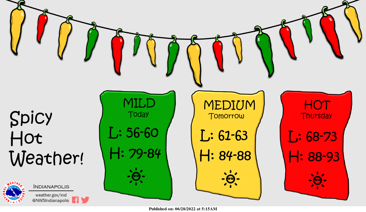
Let's taco-bout the spicy weather that's headed our way!
Be sure to drink lots of water as temperatures heat back up into the 90s.
INDIANAPOLIS 7-DAY EXTENDED FORECAST
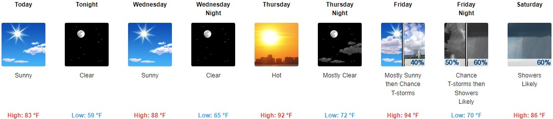
Today: Sunny, with a high near 83. Calm wind.
Tonight: Clear, with a low around 59. Light and variable wind.
Wednesday: Sunny, with a high near 88. Calm wind becoming west southwest around 6 mph in the morning.
Wednesday Night: Clear, with a low around 65. West wind around 6 mph becoming calm in the evening.
Thursday: Sunny and hot, with a high near 92. Light south southeast wind becoming south southwest 5 to 10 mph in the morning.
Thursday Night: Mostly clear, with a low around 72.
Friday: A 40 percent chance of showers and thunderstorms after 2pm. Mostly sunny and hot, with a high near 94.
Friday Night: A chance of showers and thunderstorms, then showers likely and possibly a thunderstorm after 2am. Mostly cloudy, with a low around 70. The chance of precipitation is 60%.
Saturday: Showers likely and possibly a thunderstorm before 8am, then a chance of showers between 8am and 2pm, then showers likely and possibly a thunderstorm after 2pm. Mostly cloudy, with a high near 86. The chance of precipitation is 60%.
Saturday Night: Showers likely and possibly a thunderstorm before 8pm, then a chance of showers. Mostly cloudy, with a low around 67. The chance of precipitation is 60%.
Sunday: A 40 percent chance of showers. Mostly sunny, with a high near 86.
Sunday Night: A 20 percent chance of showers. Mostly clear, with a low around 68.
Monday: A 20 percent chance of showers and thunderstorms. Mostly sunny, with a high near 89.
THE UNITED STATES OF AMERICA 3-DAY OUTLOOK


SOURCE: NWS Indianapolis.
Follow NWS Indianapolis on Twitter @NWSIndianapolis for the latest Indianapolis area weather news.