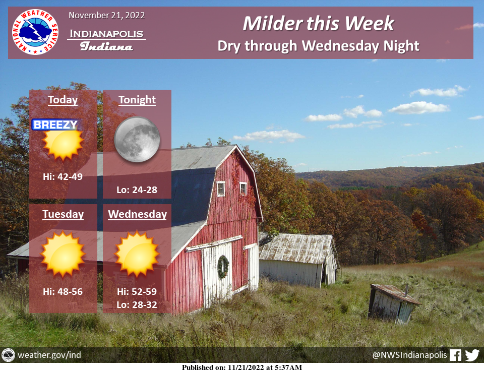
Milder temperatures are expected through much of the week, with highs well into the 50s mid-week.
Breezy conditions can be expected today, with wind gusts 25 to 35 MPH.
Skies will be mostly clear through Wednesday.
Rain chances return on Thanksgiving.
ELEVATED FIRE THREAT THIS AFTERNOON
Gusty winds up to 25 to 30+ mph in addition to relative humidity values dropping into the upper teens to lower 20s will lead to an elevated fire threat through the afternoon and early evening hours.
Avoid outdoor burning when possible and properly dispose of any flammable objects.
INDIANAPOLIS 7-DAY EXTENDED FORECAST
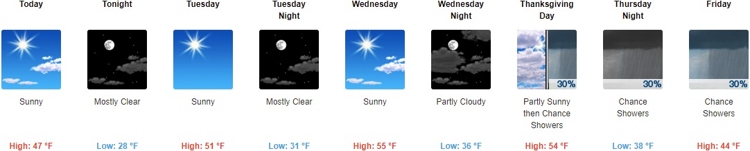
Today: Sunny, with a high near 47. Southwest wind 11 to 15 mph, with gusts as high as 30 mph.
Tonight: Mostly clear, with a low around 28. Southwest wind around 6 mph becoming calm in the evening.
Tuesday: Sunny, with a high near 51. Calm wind becoming southwest 5 to 7 mph in the morning.
Tuesday Night: Mostly clear, with a low around 31. Southwest wind 3 to 5 mph.
Wednesday: Sunny, with a high near 55. Calm wind becoming south-southwest around 6 mph in the morning.
Wednesday Night: Partly cloudy, with a low around 36.
Thanksgiving Day: A 30 percent chance of showers after 1pm. Mostly cloudy, with a high near 54.
Thursday Night: A 30 percent chance of showers. Mostly cloudy, with a low of around 38.
Friday: A 30 percent chance of showers, mainly before 1pm. Mostly cloudy, with a high near 44.
Friday Night: A 20 percent chance of showers before 1am. Mostly cloudy, with a low of around 34.
Saturday: Mostly sunny, with a high near 49.
Saturday Night: Partly cloudy, with a low around 34.
Sunday: Mostly sunny, with a high near 49.
THE UNITED STATES OF AMERICA 3-DAY OUTLOOK


SOURCE: NWS Indianapolis.
Follow NWS Indianapolis on Twitter @NWSIndianapolis for the latest Indianapolis area weather news.