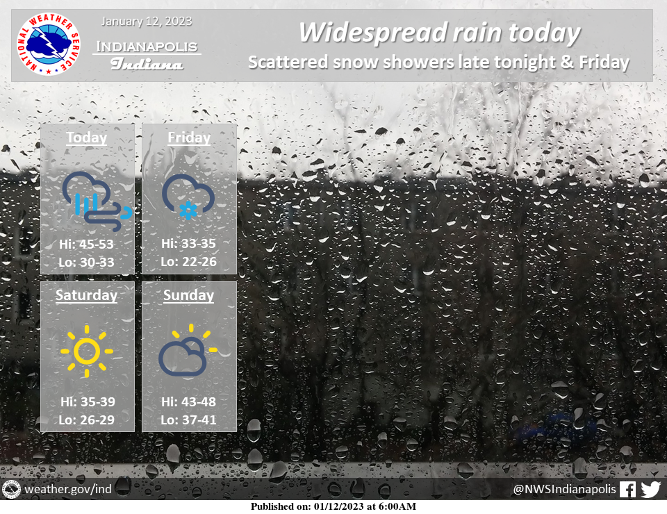
Expect widespread rain and breezy conditions today as a surface low moves through.
Scattered snow showers will be possible tonight and Friday with colder air moving in behind the system.
Look for temperatures to rebound by late this weekend.
INDIANAPOLIS 7-DAY EXTENDED FORECAST
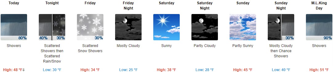
Today: Showers, mainly before 5pm. Temperature falling to around 42 by 5pm. North northwest wind 15 to 17 mph, with gusts as high as 26 mph. The chance of precipitation is 80%. New precipitation amounts between a quarter and half of an inch possible.
Tonight: Scattered rain showers before midnight, then scattered rain and snow showers between midnight and 4am, then scattered snow showers after 4am. Cloudy, with a low of around 30. North northwest wind 13 to 17 mph, with gusts as high as 29 mph. The chance of precipitation is 40%.
Friday: Scattered snow showers. Cloudy, with a high near 34. North northwest wind around 15 mph, with gusts as high as 24 mph. The chance of precipitation is 30%.
Friday Night: Mostly cloudy, with a low of around 25. North northwest wind 9 to 14 mph, with gusts as high as 24 mph.
Saturday: Sunny, with a high near 38. North northwest wind 5 to 9 mph.
Saturday Night: Partly cloudy, with a low around 28.
Sunday: Partly sunny, with a high near 45.
Sunday Night: A 30 percent chance of showers after 1am. Cloudy, with a low of around 40.
M.L.King Day: Showers. High near 51. The chance of precipitation is 90%.
Monday Night: Showers likely, mainly before 1am. Mostly cloudy, with a low of around 44. The chance of precipitation is 60%.
Tuesday: Mostly cloudy, with a high near 52.
Tuesday Night: Mostly cloudy, with a low of around 37.
Wednesday: A 50 percent chance of showers. Mostly cloudy, with a high near 51.
THE UNITED STATES OF AMERICA 3-DAY OUTLOOK


SOURCE: NWS Indianapolis.
Follow NWS Indianapolis on Twitter @NWSIndianapolis for the latest Indianapolis area weather news.