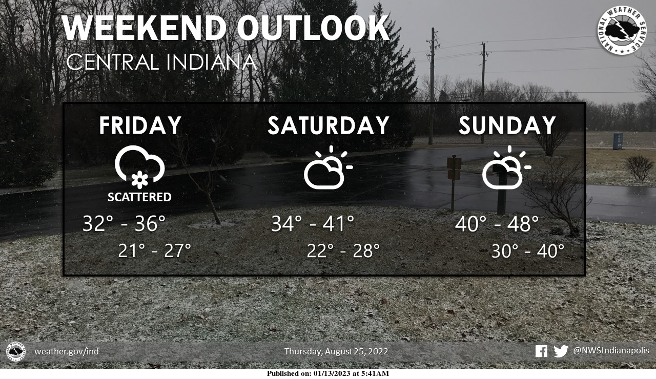
Scattered snow showers and nearly steady temperatures in the low to mid-30s are expected today.
Minor accumulations cannot be ruled out.
Dry and slowly warming conditions are expected through the weekend.
Rain returns early in the work week.
INDIANAPOLIS 7-DAY EXTENDED FORECAST
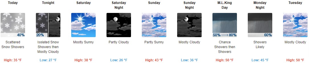
Today: Scattered snow showers, mainly before 4pm. Cloudy, with a high near 35. North northwest wind around 14 mph, with gusts as high as 23 mph. The chance of precipitation is 40%.
Tonight: Isolated snow showers before 8pm, then scattered flurries between 8pm and 9pm. Mostly cloudy, with a low of around 27. North northwest wind 8 to 14 mph, with gusts as high as 23 mph. The chance of precipitation is 20%.
Saturday: Mostly sunny, with a high near 38. North northwest wind around 6 mph becoming calm in the afternoon.
Saturday Night: Partly cloudy, with a low around 26. Light and variable wind.
Sunday: Partly sunny, with a high near 43. South southeast wind 5 to 10 mph.
Sunday Night: Mostly cloudy, with a low of around 36.
M.L.King Day: Showers, mainly after 1pm. High near 50. The chance of precipitation is 80%.
Monday Night: Showers likely, mainly before 1am. Mostly cloudy, with a low of around 45. The chance of precipitation is 60%.
Tuesday: Mostly cloudy, with a high near 50.
Tuesday Night: Mostly cloudy, with a low of around 39.
Wednesday: A 30 percent chance of showers. Mostly cloudy, with a high near 51.
Wednesday Night: Showers likely. Cloudy, with a low of around 43. The chance of precipitation is 70%.
Thursday: A 50 percent chance of showers. Partly sunny, with a high near 53.
THE UNITED STATES OF AMERICA 3-DAY OUTLOOK


SOURCE: NWS Indianapolis.
Follow NWS Indianapolis on Twitter @NWSIndianapolis for the latest Indianapolis area weather news.