
A Freeze Warning is in effect late tonight into Saturday morning for all of central Indiana, as low temperatures will range from 28-31 degrees across the area tonight.
Protect sensitive vegetation, as the growing season has begun.
ECLIPSE FORECAST

While uncertainty remains, there are signs that skies may be clearing by Monday afternoon for the upcoming eclipse.
There is at least a 30-50% chance that total sky coverage will be 50% or greater, but that does not mean all cloud cover will be thick and opaque.
NEXT 12 HOURS
NEXT 12-24 HOURS

INDIANAPOLIS DAILY CLIMATE DATA

INDIANAPOLIS 7-DAY EXTENDED FORECAST

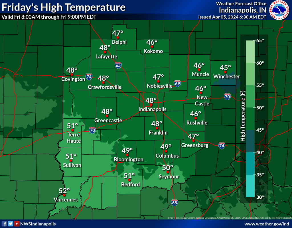
Today: Isolated showers between 2pm and 3pm. Cloudy, with a high near 48. North northwest wind around 10 mph. Chance of precipitation is 20%.
Tonight: Patchy fog after 5am. Widespread frost, mainly after 2am. Otherwise, partly cloudy, with a low around 30. North northwest wind 6 to 10 mph.
Saturday: Patchy fog before 10am. Widespread frost before 10am. Otherwise, sunny, with a high near 55. North wind around 6 mph.
Saturday Night: Mostly clear, with a low around 38. East southeast wind 6 to 9 mph.
Sunday: Showers likely, with thunderstorms also possible after 5pm. Partly sunny, with a high near 59. Southeast wind 11 to 17 mph, with gusts as high as 25 mph. Chance of precipitation is 70%. New rainfall amounts of less than a tenth of an inch, except higher amounts possible in thunderstorms.
Sunday Night: Showers and thunderstorms likely before 11pm, then scattered showers between 11pm and 2am. Mostly cloudy, with a low around 48. Southeast wind 14 to 17 mph, with gusts as high as 25 mph. Chance of precipitation is 60%. New precipitation amounts between a tenth and quarter of an inch, except higher amounts possible in thunderstorms.
Monday: Mostly sunny, with a high near 72. Southwest wind 11 to 17 mph, with gusts as high as 25 mph.
Monday Night: Isolated showers after 2am. Partly cloudy, with a low around 50. South southwest wind 10 to 14 mph, with gusts as high as 21 mph. Chance of precipitation is 20%.
Tuesday: Scattered showers and thunderstorms, mainly after 8am. Partly sunny, with a high near 69. Southwest wind 8 to 11 mph, with gusts as high as 18 mph. Chance of precipitation is 30%.
Tuesday Night: Scattered showers and thunderstorms, mainly after 2am. Mostly cloudy, with a low around 51. West southwest wind 8 to 10 mph becoming south southeast after midnight. Chance of precipitation is 40%.
Wednesday: Scattered showers and thunderstorms. Partly sunny, with a high near 67. Chance of precipitation is 50%.
Wednesday Night: Showers and thunderstorms likely. Mostly cloudy, with a low around 53. Chance of precipitation is 60%.
Thursday: Showers likely and possibly a thunderstorm. Mostly cloudy, with a high near 67. Chance of precipitation is 60%.
THE UNITED STATES OF AMERICA 3-DAY OUTLOOK


SOURCE: NWS Indianapolis.
Follow NWS Indianapolis on Twitter @NWSIndianapolis for the latest Indianapolis area weather news.
Leave a Reply